Friday, 17 July 2020

Keir Brae and a walk round Loch Ore

16 July 2020

Participants: Neil and Ben

Where: Keir Brae, 139.4m/457', P. 30.7m, Tump, OS 58, NT 237 945

Another trip to Fife this time to bag another of the new Tumps- Keir Brae at Cardenden. The use of Lidar technology is making measurement more accurate but is a bit of a two edged sword for hill baggers; hills are being added to the lists but at least an equal number are being deleted. I feel as if I'm bagging to stand still!

There was plenty parking available and a good track into the wood and then a network of paths through it. There was a trig which wasn't the high point but which I visited anyway. The views to the north from the edge of the wood took in the Lomond Hills. The high point was in the higher trees at the edge of a steep drop down towards the busy A92. 


It was still early in the day so I drove to Lochore Meadows Country Park for a walk around the loch. The car park area was busy but we only had to walk a few hundred yards to get away from the crowds. The park is well kept and impressive- a redeveloped coal mining area, much improved since the only other time I had been there. The loch walk is 3.5 miles long on a good track with great views of the Marilyn, Benarty Hill. Really nice and must be even more interesting in winter when all the over wintering birds are present.


Monday, 13 July 2020

Winton Hill, Carfrae Hill, Redstone Rig and Arniston Colliery Bing

11 July 2020
Participants: Neil and Ben

Where: Winton Hill, 132m/433', P.36m, Tump, OS 66, NT 438709; Carfrae Hill, 226m/741', P.47m, Tump, OS 67, NT 572684; Redstone Rig, 441m/1,447', P.54m, Tump, OS 67, NT 608644; Arniston Colliery Bing, 182m/598', P.33m, Tump, OS 66, NT 339620


I always enjoy a trip to East Lothian, it is very pleasant countryside in a genteel sort of way. For this visit, I had planned a circular route taking in 4 Tumps roughly centered around Gifford. First up was Winton Hill, a wooded top just south of Tranent. It made a very pleasant start to the day with good paths apart from around the summit area which was a mix of scrub and brambles......


The strip of trees was narrow so only slight diversions were needed to get to the edge to take in the views. South to the Lammermuir Hills.....


North-west to the Pentland Hills.....


Over a field of corn to Fife.....


I then drove south through Gifford and turned off at Danskine on to a minor road which took me almost to the top of Carfrae Hill. There was a convenient field entrance in which to park, then a short walk up the road and through a gate at the edge of some trees and a few yards into a field saw me at the high point. Couldn't be easier! Another view towards the Lammermuir Hills and another field of wheat this time looking towards North Berwick Law and Traprain Law.....


Continuing south, I was soon in moorland. I find the Lammermuir Hills bleak and unwelcoming not helped by "Keep Out" notices and vast grouse shooting areas. And yet there is a sense of openness and beauty. Redstone Rig was the target, fortunately only a short walk from the road as the conditions underfoot were a mix of tussocks and heather, not nice. For some reason, there was a cairn on this insignificant bump......


The view north to the Pentland Hills.....


and south to the Cheviot......
 

Back to the car, I reversed the route as far as Pencaitland and then cut across country to Arniston to add another of the new Tumps, Arniston Colliery Bing. This one looks much more like a natural hill than some of the other bings on the Tump list. There was easy parking, a good path up, and a glimpse of the Pentland Hills from near the top.....


Tuesday, 7 July 2020

A Couple of Most Unusual TUMPS: St Ninian's, Fife

6 July 2020

Participants: Neil and Ben

Where: St. Ninian's East, 181m/594', P.49m, Tump, OS 58, NT 131924 and St. Ninian's West, 170m/558', P.32m, Tump, OS 58, NT 125926: Hillfield Crescent, 77m/255', P.34m, Tump, OS 65, NT 126830

These are two of the “new” Tumps and an unusual pair they are. They stand in the middle of what used to be a vast open-cast coal mine between Kingseat and Kelty in Fife. I read somewhere that the site comprises 930 acres and the mining village of Lassodie once occupied part of this land. When the mine closed, the owners, Scottish Coal commissioned landscape artist Charles Jencks to develop a landform which it was intended would transform the area and provide a major attraction. But no sooner was work started than it ended when the owners went into administration. Charles Jencks was also the founder of the Maggies Cancer Centers.

There are apparently still hopes that the site will eventually be used for a major leisure project but for now, nature has taken over, the area is a green, if not completely pleasant, land and of benefit to dog walkers and Tump baggers.

I started the walk from the Thornton Woods entrance to the north. This gave me a longer walk but also meant that I was starting near what was the rim of the quarry so it was all downhill initially. And of course uphill coming back.

From the approach track.....


I visited the east hill first, the higher of the two and the most interesting. Ben on the approach.....


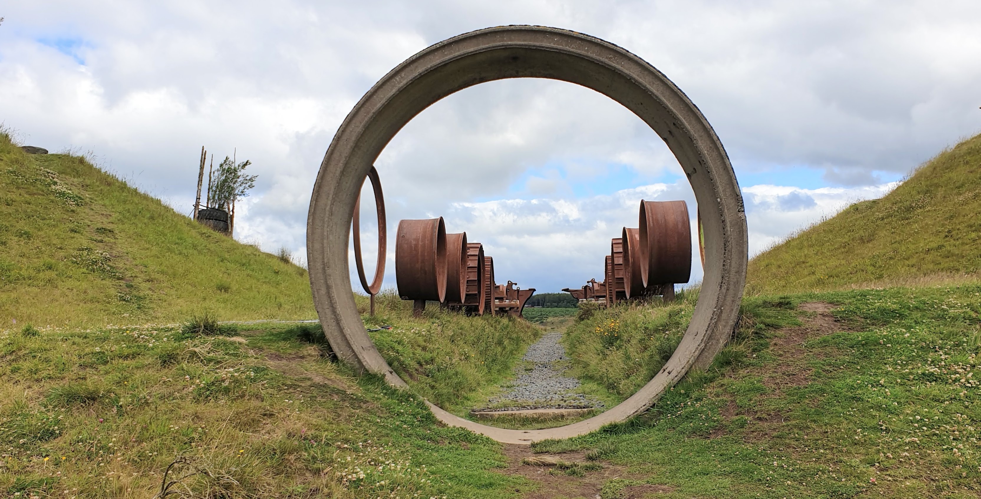
There are two ways up, a long, easily graded track that winds its way round and round the hill or a number of steeper shortcuts- we did a combination of the two. The hill has three tops, all of about equal height, and all adorned with artwork comprising old tyres and trees with other bits and pieces lying around- all unfinished sculptures. The best exhibit was an avenue of old mining machinery. It would have been good if it had been finished.....


We wandered around having a look at all the exhibits before setting off again for the West Hill, much the inferior of the two. Knock Hill at Saline was on the horizon.....


The West Hill had a narrow summit ridge with a couple of tops and not being able to decide which was higher we did them both.....


Then it was back down to the track and uphill to the car. An unusual hill walk, but interesting. Anybody doing the Tumps had better do these two before the area becomes a theme park!

I drove home by Inverkeithing so that I could also bag another new Tump- Hillside Crescent- which as its name implies is now a housing scheme. The high point however was a patch of grass so better than another new Tump in Kilsyth......


Friday, 26 June 2020

Gartcarron Hill East, a new Tump in the Campsies

24 June 2020
Participants: Just me. I am a bit worried that Ben is developing a weakness in his front legs so I will probably leave him at home until his next visit to the vets.

Where: Gartcarron Hill East, 389m/1,032', P 30.6m, Tump, OS 57/64, NS 654 848

Another of the hills that has been resurveyed and this time one very close to home in the Campsie Fells. I had already done Gartcarron Hill but its east top although over the 30m prominence mark, was very different. The main top was in pasture, this one was in a forest, most easily reached from the Meikle Bin car park at xxxx. The warm weather had brought out the crowds and I had to park further down the road as the car parking area was full. However everyone was clearly bound for either the reservoir or Meikle Bin and I saw no one after leaving the main track.  I soon turned off the main track on to a disused one. The walking was very pleasant with broom bushes in places, apart that is from the swarms of flies. Summer has arrived!


The track continued all the way to the summit area. Unfortunately the high point was in the trees, somewhere around here.....


It was back the same way, a very pleasant short day. There was a good view of the two tops from the Crow Road on the way back. 


Thursday, 18 June 2020

King's Seat Hill (Clackmannan)

18 June 2020

Participants: Just me
Where: King's Seat Hill (Clackmannan), 58m/192', P. 33m, Tump, OS 58, NS 906 919

This is another of the newly promoted Tumps and one that fully justifies its status. It is crowned by Clackmannan Tower with the high point of the hill close to the north wall. The Tower has lots of Royal connections. It is thought that Royalty might have first used the site in the reign of Malcolm IV in the 11th century. The earliest part of the Tower seems to date from the early 14th century, extensive alterations took place in the 1400's and a mansion house, now demolished, was added in the late 1500's. The occupants were descendants of relatives of Robert the Bruce and they occupied the Tower until the late 1700's. At present, the tower can only be viewed from the outside, which is a pity as there must be an even better view from the top.


I parked at the top of the main street close by the old Tollbooth and Mercat Cross.....


The Tower was only a short distance away. As I expected, the hill was a wonderful viewpoint. The Ochil Hills are a short distance to the north and this viewpoint revealed Ben Cleuch, the highest, which hides away from lower down.....


There was also a great view of Dumyat through the trees from just west of the Tower.....


The view south over the Forth to the lowlands was a bit industrial!


Monday, 1 June 2020

Bellahouston Park (Glasgow)- a new Tump

1 June 2020

Participants: Neil and Ben
Where: Bellahouston Park, 50.2m/165', P 30m, Tump, OS 64, NS 549 638.

The tamperers have been busy checking heights across Great Britain and as a result are discovering a whole lot of new Tumps. They are also finding existing Tumps that are in fact below the required prominence and therefore deleting them from the list, Only one of my climbed hills have been "lost" that way, thank goodness. And I now have at the present count 10 new Tumps that I can visit as easy day trips. I did the first of them today- a short drive across Glasgow to Bellahouston Park.

I parked off road on the south side at one of the entrances. This is the view of the high point from the start.....


Bellahouston is one of the largest parks in Glasgow- about 180 acres- and it was certainly very easy to maintain social distancing. The park housed the Empire Exhibition of 1938, the visit of Pope John Paul II in 1982 and numerous pop concerts and other events. We headed firstly (of course) for the high point.....


There was no view from the high point but a short distance to the edge of the trees found a fine view over Mosspark and the south of the city.....


After the summit, we wandered down the north side of the hill to have a look at Charles Rennie Macintosh' House for an Art Lover; from the outside only unfortunately as all public buildings are still closed due to the pandemic.....


Nearby, Ben found a new friend.....


There were also a number of sculptures.....


and some nice trees.....


All in all, it was a very pleasant hour or so. Not a "real" hill but another Tump bagged.