Thursday 31 August 2023

Black Hill (near Abington)

 30 August 2023

Where: Black Hill, 383m/1,258', P 100m, Hump, OS 71/72, NS 904 243

The weather had changed for the better as autumn approached. I decided on a short walk and drove down towards Abington, taking the old road as I got south and parked up opposite the house at Strand where there was space for a couple of cars. I climbed a gate onto the hillside and followed a track and then sheep trods to the small pile of stones that marked the summit. It was a gentle ascent. Fine open views as I got higher. Tinto dominated the eastern view......


Lots of wind farms, looking towards Crawfordjohn....

Looking south east, the M73 was in view in this direction and I could hear the noise of the traffic......


Thursday 24 August 2023

Bizzyberry Hill (Biggar)

 24 August 2023

Where: Bizzyberry Hill, 363m/ 1,191', P 112m, Hump, OS 72, NT 047 393

Visibility is at its best after rain and today was a great example. It had rained overnight but had cleared by the time I set off for Biggar to climb Bizzyberry Hill. I parked in the town and walked to its east end where there was a signposted path to the hill. This went all the way to the summit through a couple of fields and a steep finish up the front of the hill itself. Part way up there is an information board which provided all that I needed to know about the hill.....

I stopped a few times on the way up to admire the view behind me. Culter Fell and then Tinto,,,,,


Soon my hill came into view.....

and the path narrowed and went through a couple of fields. As this is a Core Path there were pedestrian gates through the fences. Leaving the fields behind the path narrowed considerably and got a great deal steeper as it passed through an area of gorse. It was back on the grass above the steep bit and the summit was in sight. Just before I got there, I passed this stone, handy if you've forgotten where you are! Tinto beyond.....

Strange that it is not on the summit which is a bit further on, on land which clearly belongs to someone else as there is a barbed wire fence to get past. Here I went slightly down hill to the north where there was a gate (but no pedestrian gate). There was another good view of Tinto from here.....

The views from the summit were superb. No wonder the Iron Age people built a fort here. To the east the Broughton Hills.....

To the south Biggar and the Culter Hills.....

and to the west Biggar and Tinto.....

An excellent hill seen at its best.


Saturday 12 August 2023

Blake Muir

8 August 2023

Where: Blake Muir, 467m/1,532', P 34m, Tump, OS 73, NT 302 306

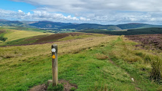
 It was more like a day in May than in August when I parked in the large car park next to Traquair church south of Innerleithen. Occasional showers were forecast but for the most part it remained dry and very clear. The route of the Southern Upland Way left the road next to the car park and climbed gently passing very close to the high point of Blake Muir. With stiles over all of the fences, it was a delightful uncomplicated walk with good views, one of the best that I had had this year. The track started steeply but I was soon out on the moor with my intended summit looking a long way in the distance (it was in fact less than 3 miles away).  The target was the pointed hill to the left centre in the second photo.....


Getting a bit closer.....


The eastern ridge of the Peebles-Dun Rig horseshoe was on my right hand side as I ascended.....

There were good views back to Innerleithen and I took a number of photos as I got higher.....


and looking east to the Minch Moor, a hill that I had climbed a number of times.....

The heather was in full bloom; really colourful this year.....

It was quite cold near the top and I had to stop to put on my jacket. The SUW ran between the two tops of Blake Muir, the higher was to the east and sported a small cairn which was actually about 30m north of the actual high point.....

Another excellent Tumping day out!