Tuesday 22 August 2017

Hills among windmills

21 August 2017
 
Participants: Neil and Ben
Where: Blackwood Hill, 309m/1014', Tump, OS 64, NS 544 484 and Ballageich Hill, 333m/1,093', Tump, OS 64, NS 532 502
 
Todays dog walk was among the windmills at Whitelee windfarm. Not sure if it is still the largest in the UK but if not, its successor must be huge. I don't mind turbines, if they are in the right place. Whitelee, which is desolate moorland to the south west of Glasgow, is in my view ideal. Scottish Power have done a great job here, creating a leisure area in amongst the turbines for walkers, dog walkers, runners, cyclists, horse riders. There are a number of signposted routes, the longest of which is 22 miles, which gives an indication of the scale of the place. Their publicity blurb says that the windfarm covers an area greater in size than Glasgow. And there is a visitor centre with an excellent cafĂ©.
 
There was of course an ulterior motive in us going to Whitelee- the area contains a number of Tumps. Blackwood Hill was on the to do list, only a couple of miles from the visitor centre. This is a view of it from the road to the north; the hill is the long ridge towards the centre right of the photo.....
 
 
The moorland about here certainly is rough.....
 
 
But the turbines in this setting are fine, at least to my eyes and ignoring thoughts of the subsidies paid to the companies for actually generating electricity (and for not generating electricity).....
 
 
We walked past the end of Lochgoin reservoir....
 
 
and up a path to the top of Blackwood Hill, on which Scottish Power have built a topograph and have placed seats for visitors to sit and enjoy the view.....
 
 
I had intended to carry on to do Dunwan, another Tump, but the local farmer had unhelpfully decided to park a herd of sheep on the approach slopes and as I didn't fancy being dragged up and down the hill by an excitable spaniel I decided to leave this one for another day. So it was back to the visitor centre for a cup of coffee and on with plan B.
 
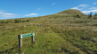
This involved a short drive along the road to a layby at the foot of Ballageich Hill, which is outwith the windfarm. This was much more like a real hill, tussocks and upland bog. There were traces of a path.....
 
 
but generally it was find your own way to the small pile of stones that apparently marked the highest point.....
 
 
The views weren't bad for a hill of this height, north to Glasgow with the Campsie Fells beyond (you can make out the distinctive shape of Dumgoyne).....
 
 
and west to the Ayrshire coast with the Arran peaks just visible in the distance.....
 
 
A short day, but it was all that I was looking for as the clouds were steadily building up.

Monday 14 August 2017

Ben Shee (Ochils)

13 August 2017

Participants: Neil and Ben
Where: Ben Shee, 516m/1,693', Tump, OS 58, NN 952 039

I was back in the Ochils quicker than expected! There was a good weather forecast for the morning but with rain then moving in from the afternoon. So a walk in the east seemed best. This time I parked further up Glendevon in the Woodland Trust Glen Sherup car park. A marked Trail which goes all the way to the summit of Ben Shee starts from there. The first mile or so is through Forestry Commission conifers after which a path drops down to the head of Glensherup reservoir. There were a lot of boats out and there was a fine view along the water to the upper glen with Tarmangie Hill in the far distance.....
 
 
We crossed the reservoir dam, passed the fishermen's' hut and went through a gate on to Woodland Trust land. Just as well there was a path- the ferns were head high.....
 
 
The Trust has planted thousands of trees and they are certainly a big improvement on the conifer plantations. However, they look as though they are going to become almost as impenetrable in places. Ben Shee came into sight above us.....
 
 
The path went well past the end of the reservoir before it took a right turn and headed up hill. There was a fine view back spoiled somewhat by the Steele's Knowe wind turbines.....
 
 
The path went up the west side of Ben Shee.....
 
 
and eventually levelled out providing a view into the next glen. Not sure what it's called- maybe it's the upper reaches of Glendevon as it contains the two Glendevon reservoirs.......


There was no chance of getting lost.....
 
 
and we were soon at the summit. There was nothing to mark the spot but it was a fine perch, with Fife's Lomond Hills in the background.....
 
 
I reckon that this is one of the best viewpoints in the Ochils. You are looking straight up Gleneagles with Ben Chonzie and its surrounding hills in the distance..... 
 
 
The two Glendevon reservoirs.....
 
 
And I think best of all a view of the wide expanse of this range of hills with Ben Cleuch in the distance. Just a pity about the wind turbines. You could wander for miles up here without seeing anyone else; I certainly had it to myself while I would imagine that the higher hills around Ben Cleuch would have had a steady stream of visitors......
 
 
Ben certainly liked it!.....
 
 
We could have carried on over the hill and made a round but I thought that there might be sheep on the non-Woodland Trust land so decided just to go back the same way. A good way to spend a Sunday morning and I spotted plenty more hills that I hadn't yet visited.

Sunday 13 August 2017

Commonedge Hill (Ochils)

9 August 2017

Participants: Neil and Ben
Where: Commonedge Hill, 468m/1,535', Hump, OS 58, NN 980015
 
Commonedge Hill is one of the lower of the Ochils lying on their southern edge at the entrance to Glendevon. As far as I am aware, I had not climbed it before. The start point was the car park at the side of Castlehill reservoir, initially following a road that went to the houses at Glenquey. This part of the hill was bought by the Woodland Trust a few years ago and the new planting is impressive. They have also been planting across the valley on the slopes of Innerdownie; what a difference from the previously bare hillside.....
 
 
Beyond the Woodland Trust land I was into good old fashioned Forestry Commission conifers; at least they provide good tracks to walk on. There was an occasional glimpse of Glenquey reservoir below but mostly it was the usual shut in forest view.....
 
 
The track wound its way gradually across and up the hillside for over a mile to emerge suddenly on the west ridge of Commonedge Hill, not far from the highest point. The view that greets you is quite impressive, taking in most of central Scotland. I could see the Arran hills, Tinto, the Pentlands, North Berwick Law.....


Some of the higher hills of the Ochils blocked out the westerly view......
 
 
but it was clear to the east, over Loch Leven to the Fife Lomonds.....
 
 
We had a break at a convenient style not far from the highest point.....
 
 
Although I've done all of the higher hills of the Ochils many times, I now see from the hillbagger website that there are a lot of others that make the lists and that I have never visited. Should make for some more good trips.

Wednesday 9 August 2017

Humping and Tumping along Hadrian's Wall

6 August 2017

Participants: Me and Peter King
Where: Highshield Crags, 283m/928', Tump, OS 86/87, NY 764 678, Hotbank Crags, 327m/1,073', Tump, NY 776 685, and Winshield Crags, 345m/1,132', Hump, NY 742 676
 
The forecast for the morning was reasonable but heavy rain was forecast to move in in the afternoon so a shortish walk was in order before I drove back to Scotland. I had been to Hadrian's Wall before but the section above Once (and Twice!) Brewed would be new to me and also a really interesting part of the Wall so we drove east and parked in Peel car park. I had no idea that any of the points that we would be walking over made it into the hill lists although when we got to Winshield Crags and found a trig point on top I did start to wonder.
 
The Wall is justifiably a World Heritage Site. It is the most important monument built by the Romans in Britain and for nearly 300 years was the north-west frontier of an empire that stretched east for 2,500 miles and south for 1,500 miles to the deserts of Africa. Built to separate the Romans from the barbarians, i.e., us, it is 73 miles long and crosses the country from Bowness-on-Solway to Wallsend on the Tyne. It was built as a frontier control; nothing much changes does it Mr Trump and the Brexiteers. As well as the Wall itself, there are a series of forts, barracks, milecastles, gates, bath houses and turrets. And of course, modern day visitor centres and exhibitions. Built on the orders of Emperor Hadrian in the 120's it was eventually abandoned at the start of the 5th century. Really interesting and I would imagine that to walk the entire length would be a magnificent expedition- takes about a week apparently.
 
We decided to walk east from Peel over a very up and down section of the Wall. This is from very near the start of the walk looking to Peel Crags, Highshield Crags, Crag Lough and Hotbank Crags the high point in the distance.....
 
 
The route of the Wall is now a National Trail and the steeper sections now seem to be paved; if the number of walkers that we met is representative of its popularity then they would need to be in order to protect the environment. The weather was so so- a bit dull but perfectly clear. The path at least in this section follows closely the Wall itself, switching sides from time to time. This is on Peel Crags and shows the undulating nature of the route as well as showing the thickness of the Wall.....
 
 
Moving on towards Highshield Crags, we passed Milecastle 39, one of many guardposts that were built at intervals of one Roman mile to control movement across the Wall.....
 
 
The highest point of Highshield Crags which I later discovered was a Tump, was on the north side of the Wall above the west end of Crag Lough.
 
The path dipped again to pass Hotbank farm above which was another high point- Hotbank Crags, again subsequently found to be a Tump. This is the path ascending Hotbank Crags, the most easterly part of our walk.....
 
 
There was a good view back from here over the section that we had come and on to the impressive looking Winshield Crags in the far distance.....
 
 
More similar views of Crag Lough, Highshield Crags (mostly tree covered), Peel Crags, the single clump of trees which contains Peel car park and then Winshield Crags in the distance.....


Rather than go back over the high parts of the Trail, we dropped down below it on the south side where there was a low level trail. However, we went back up again at Peel Crags where I took this photo of Winshield Crags with Peel wood car park in front of it....
 
 
Getting closer.....
 
Winshield Crags looked as though it would provide a good view westwards so we passed the car park and carried on to its summit. Right enough there was a good view to the northern Pennines with Cold Fell prominent.....


The weather was starting to look a bit threatening so we decided to call it a day. I will be back though to explore more of this fascinating area.

I had only driven as far as Longtown on the way home when the rain arrived; it bucketed down all the way till I got to about Hamilton.


Monday 7 August 2017

Strangely named hills.....

4 August 2017

Participants: Just me
Where: Repentance Hill, 113m/371', Tump, OS 85, NY 155 722 and Woodcock Air, 129m/423', Tump, OS 85, NY 171 722
 
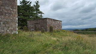
I was driving south to an MBA meeting in the north of England and wanted to take in a hill on the way. These two, north of Annan, caught my eye on the map due to their strange names. So I left the motorway at Ecclefechan and after a few miles on the B725 arrived at a woodland car park just over Hoddom Bridge. I went to Repentance Hill first; a walk along the road of about a mile brought me to a signed path to Repentance Tower which crowned the hill.....

 
Although the hill is named Repentance Hill on the Database of British Hills website, it seems as though that is really only the name of the tower and that the hill should be called Trailtrow Hill. Anyway, it is the tower that is the main interest.......
 
 
It was built in the 1560's by Sir John Maxwell, 4th Lord Herries as a watchtower for Hoddom Castle, which he also built. It was fitted with a large bell and a platform for a beacon. Unfortunately, it is now firmly locked so you cant get in. It was apparently named as an act of repentance by Lord Herries who had betrayed members of his family in order to make an advantageous marriage.
 
The tower is part of a graveyard which has many stones dating from the 17th century. Sadly, it doesn't seem to be tended nowadays despite the historical connections......


Despite its low height, there is a fine view to the Solway Firth with the familiar peak of Criffel beyond.....


The view north takes in Hoddom Castle, now part of a holiday complex.....


There was another Tump across the valley- the intriguingly named Woodcock Air......
 
 
I cant find anything that tells me the origin of the name. Although it is heavily wooded, there is a network of paths through the wood, all signposted and with the grass obviously regularly cut so it was a pleasant walk. One path started at the car park and I then simply followed whichever path seemed to be heading for the top. There was one viewpoint high up, looking west over Repentance Hill to Criffel......
 
 
Off the path, there was a lot of wind blown timber and I almost missed the trig.....
 
 
To make a longer walk, I dropped down another path to the south side of the hill where there was a view over the flat lands to the Solway.....


A pleasant and interesting pair of hills.