Thursday 23 August 2012

A foray into Northumberland: Long Crag and Ros Hill

22 and 23 August 2012.

Participants - Neil and Ben

Where - Long Crag, 319m/1,047', Sub-2k Marilyn, Map 81, NU 062069 and Ros Hill, 315m/1,033', Sub-2k Marilyn, Map 81, NU 081253

I find hill walking in Scotland in August a bit dicey; it's usually hot and sticky, frequently wet, and of course its the height of the midge season. So, for a change, I headed to.....


Northumberland is a part of the country that I've never really explored. Dawson's book said that there were a number of Marilyns in the north-east part of the county, the weather forecasters said that that was the part of the country that was likely to get most sunshine and least showers so my mind was made up. The quickest way to get there was over to Edinburgh, round the by-pass and down to Coldstream, then on to Wooler south and east of where there were a number of low lying hill ranges which contained some Marilyns.

Long Crag was my first objective. It is the highest point above some extensive forestry (Thrunton woods) north of Rothbury, where I had booked in for the night. There appeared to be a number of routes through the forest to the open moor. I didn't see a great deal of point in a long walk through trees so I took the shortest route, the most southerly of the forest tracks, starting at 092072. There was space to park three cars at the start; however bad parking by the two cars already there meant that I had to park on the verge. It was really pleasant walking through the forest.....


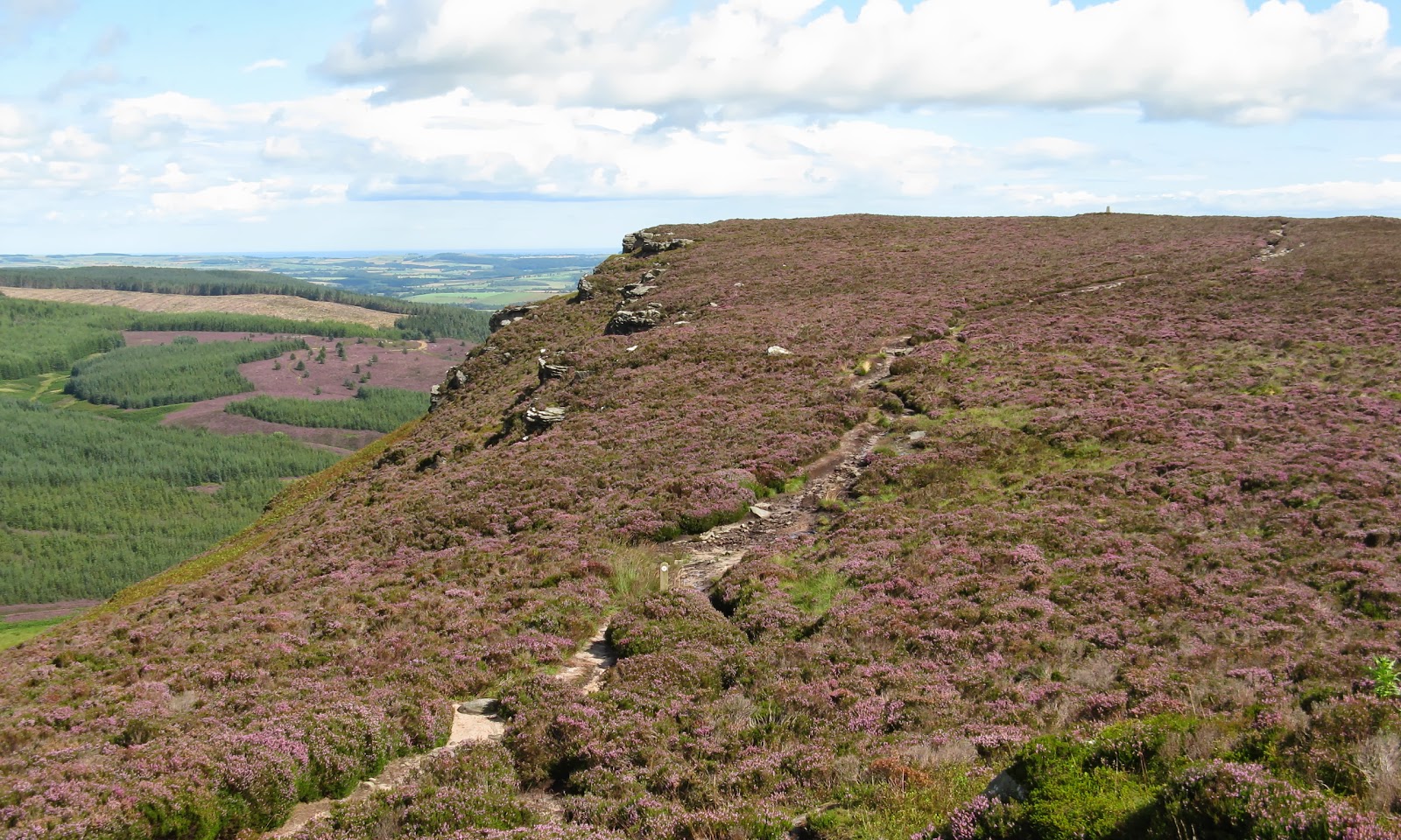
The track ended after about 1.5 miles but continued as a rough path on to the moor above where it emerged between Coe Crags and Long Crag and close to this boundary stone.....


I presume that the "S" and the "A" on the opposite side refer to old parishes but I've no idea what they were. The heather was in full bloom, the path meandered up at a gentle angle, the sun was shining....what more could I want?


 It wasn't far to the trig, where I took the obligatory pic of Ben. It's looking north with the Cheviot in the background.....


And this is looking south to the Simonside group of hills, south of Rothbury.....


The only downside to using this route was that I didn't see the crags that give the hill its name, they were below us to the north. I wandered on to a cairn on a slightly lower west top that looked as though it might give a view of the crags but I could only see the top of them from there This is looking back at the trig with the top of the crags on the left and the North Sea in the distance.....


A few showers were hitting nearby hills but we escaped them all. However, when I reached Rothbury the rain came down in earnest for about an hour so I had to hang about before I could get a wander round the town....


The following day started a bit dull. The objective was Ros Hill, south east of Wooler. It is the highest point of the Chillingham hills and is in the care of the National Trust as it has a 3,000 year old Iron Age hill fort at its summit. This is one of the easiest of the sub-2k's; from the highest point of the minor road that crosses Hepburn Moor this is all that is left to climb.....


And there is a path up! So in about 20 minutes, we were at the trig.....


The plaque on it reads.....


What it does have is an unusual toposcope built into low walls which had been constructed as an extension to the stone dyke that crosses the hill. Unfortunately, it was a bit dull so the views were not as good as they might have been. This is looking towards the coast (I could make out the castles at Bamburgh, Lindesfarne and Alnwick in the distance).....


and this one is to the Cheviot (slightly zoomed).....


The cloud on the Cheviot was starting to lift as we got back to the car.....


 and it brightened up on the drive home, where Ben went straight into the shower as he had found a particularly disgusting muddy pool on the way back down the hill!

Friday 10 August 2012

Mullach Mor (Holy Island)

9 August 2012.

Participants - Just me, dogs are not allowed on the Island.
Where - Mullach Mor (Holy Island), 314m/1,030', Sub-2k Marilyn, Map 69, NS 063297

This was one from my "must do" list. I love islands and the summit of an island which is itself offshore from another island had to be good! I wondered about going there in the middle of August, the height of the tourist season, but the weather had turned out so good that I decided that I might as well try. If things didn't work out then at least I would have had a trip to Arran. I could have done the whole trip by public transport but decided that it would be sensible to take my car to Ardrossan; there is a big car park at the ferry terminal.  But then a problem...the passenger gangway on to the Caledonian Isles had developed a fault and passengers had to get on via the car deck. And I reckon that the sailing must have been close to being full- 1,000 passengers. So we were 30 minutes late in sailing. That meant that by the time I got to Lamlash pier, I had missed the sailing to Holy Isle that I had meant to catch and the next two sailings were fully booked. Fortunately, they were operating additional sailings and I got across at 1pm. The sea was calm for both legs of the journey, this is a view of Holy Island from the Caledonian Isles......


and this is the Holy Island ferry at Lamlash harbour.....


Quoting from the Island's website "Holy Isle has a long spiritual history stretching back to the 6th century. It is endowed with an ancient healing spring, the hermit-cave of a 6th century monk, St Molaise, and evidence of a 13th century Christian monastery. The island was acquired in 1992 by the Centre for World Peace and Health as a place for peace and meditation." The boat lands close to the Centre buildings and my attention was immediately caught by the Tibetan prayer flags and a number of Stupas, "symbols of the enlightened mind of Buddha whose function is to restore, balance and transform negative energies to heal both the planet and ourselves."


The boat was met on arrival by a member of the Community who explained a bit about the Centre, the rules for visitors, and how to find the paths to places of interest. The climb was straightforward; follow the directions to the start of the hill path and take it all the way up the north ridge to the summit, with ever expanding views. The weather was absolutely glorious with excellent visibility. Here are the photos that I took on the ascent. Firstly north to the Goatfell hills.....


down to Lamlash Bay.....


 down the Firth of Clyde to Ailsa Craig.....


and the approach to the main summit from Mullach Beag.....


Eriskay ponies, Soay sheep and Laanan goats are all found on the island. The sheep were grazing down by the harbour, I saw some of the goats higher up the hill, and although there was plenty evidence that the ponies had been high up, I didn't come across any. On the way down, I spotted them by the shore on the north-east side of the island.

I was on top in just over an hour.....


Here are the photos from there; the island is very steep on its east side and there is a grand feeling of space on the top.....


Then it was back to the jetty, the boat to Lamlash, the bus to Brodick, and the ferry to Ardrossan.....


Although this trip can be done perfectly easily in a day from Glasgow, I think that it might be better to include it as part of a holiday to Arran. The bus service on the island is not great and delays on the ferry can have a knock on effect on the whole trip. At times I found that I was looking at my watch too much. And the delays in the morning meant that I didn't have time to visit the cave, the spring, the rock paintings and the lighthouse. Another visit required! A final look at Holy Isle from the boat on the way back to Ardrossan.....


Definitely a "must do again" hill.

Wednesday 1 August 2012

Nutberry Hill

31 July 2012

Participants - Just me
Where - Nutberry Hill, 522m/1,712', Sub-2k Marilyn, Map 71, NS 743338

The few reports that I'd read about Nutberry Hill commented on very rough going so I'd been putting it off; however it looked as though it might be a decent summit and as the weather window was only for one day and I'd done most of the other Marilyns close to home, I could avoid it no longer. I parked on some hard standing at the entrance to Priesthill Farm, a couple of miles north of Muirkirk on the B743. Nutberry Hill looked a long way away (probably because it was!), it is beyond the trees in the far distance in this photo.....


The first couple of miles as far as the house at Priesthill were along a good track; the view to the south was of the dominant hill in this area and a favourite of mine, Cairn Table.....


The map showed a footpath continuing after the house as far as the Martyrs Grave (the covenanter John Brown) but it very soon disappeared in some rushes and I never found it again. So I just angled up the gentle rising hillside keeping to the areas that had the shortest grass and least tufts. By keeping it slow and watching my footing it turned out to be not too bad and it didn't take too long to get to the top of Priesthill Heights where I got my first sight of the objective for the day.....


The fences up here looked quite new although they had barbed wire on top so I was glad to soon find a gate to clamber over. I then followed the fence alongside the edge of the forest, it was much rougher ground here but there were occasional motorbike tracks which helped. I crossed another fence, then a forest track, and started the long gentle ascent to the summit, helped by more 4WD tracks.....


There was a trig which was not quite at the highest point and as I had hoped, some good views from what was a quite small summit area. The visibility was excellent. This is looking towards the central belt towns.....


south east to Tinto.....


and back in the direction that I had come. Middlefield Law is the pointy hill towards the centre of the picture.....


It had been a bit of a trek, almost 5 miles, so I sat about at the trig for a while to get some strength back before setting off back the way that I had come. This is the view from Priesthill Heights with my starting/finishing point at the buildings beyond the wood in the centre of the picture.....


So it turned out not to be as bad going as I had imagined with the bonus of a fine summit viewpoint. But it is one to keep for a good day. As well as two fences that I would have had to have lifted Ben over there were a lot of sheep about so it was not a dog friendly hill.