Monday 26 June 2017

A "new" Tump- Heronryhill

26 June 2017

Participants: Just me
Where: Heronryhill, 105m/344', Tump, OS 64, NS 695 737
 
I noticed on the Hill Bagging website a couple of weeks ago that a "new" Tump had been added to the list, a couple of miles from my house, So I just had to go and have a look! I must admit that this hill had not attracted my attention before, no doubt because it was really only a bit of high ground covered in trees. In fact, it didn't look like a hill at all. Nevertheless......
 
To make it even easier, there was a road running just to the west of it with space to park a car a few hundred yards from the start of a track that went through fields to communications masts not far from the highest point. This is the hill from the start of the track.....


The track had at one time continued past the masts but today it was completely grown over. Maybe its there in winter time. There was a faint path through the grass and I soon arrived at the summit area. Slightly covered in vegetation......
 
 
Much of the summit area is taken up by a small water board reservoir, now covered over and within a locked compound..... 


Apparently the highest point of the hill is just to the south of the compound, in amongst the rhododendrons. I'll take the Hill Bagging websites word for it.
 
Surprisingly, once clear of the vegetation on the summit area, the view over west central Scotland is quite good.....


So that was my curiosity assuaged, apart from one thing. Why is it called Heronryhill? 

Wednesday 7 June 2017

Binns Hill and Linlithgow Loch

7 June 2017

Participants: Neil and Ben (loch walk only)
Where: Binns Hill, 113m/371', Tump, OS 65, NT 053786

A half day walk today- we went to Linlithgow and had a walk round the loch followed by a visit to Binns Hill, a Tump and another hill with a tower on top of it. The loch is a good stroll of just over 2 miles on a well surfaced path with great views of Linlithgow Palace.....


It's very popular at weekends but was nice and quiet today and I was able to stop and note the many species of birds that live on the loch. Ben went too close to a nesting swan and got hissed at for his trouble; I've never seen a dog jump backwards in alarm before!

It was a short drive from Linlithgow to Binns Hill which is part of the estate of the same name now in the care of the National Trust for Scotland. There appears to have been a manor house here since the 15th century. The estate was purchased by the Dalyell family in 1612 and they have lived here ever since, although the house and grounds were given to the NTS to look after in 1944. The most recent famous Dalyell was Sir Tam MP who died recently. I didn't have time today but I must do the tour next time I'm here.


It was only a short walk from the car park at the house to the hill on a marked path through woodland. The hill is topped by Binns tower- a folly erected in 1826.....


There were others at the folly......


It was a day of clear atmosphere which is why I came and the views were good for so small a hill. Looking to the Pentlands behind Edinburgh.....


North across the Forth to Fife.....


Blackness castle, the Forth and Fife.....


Up the Forth to the Perthshire hills. You can just make out Ben Ledi, Stuc a'Chroin and Ben Vorlich.....


An excellent short walk with lots of interest.

Saturday 3 June 2017

Crieff: Laggan Hill and Tom a'Chasteil and another Monument

2 June 2017

Participants: Neil and Ben
Where: Laggan Hill, 154m/505', Tump, OS 52, NN 842223 and Tom a'Chasteil (Sir David Baird's Monument), Tump, 133m/436', OS 57, NN 825217

I had spotted what looked to be an interesting walk near Crieff and as it was another nice day, off we went again. I parked in the MacRosty Park car park; what a beautifully kept park this is! Crieff is one of these towns where walkers are obviously made very welcome, there were signposted walks everywhere! Our route was across the bridge over the Turret Burn and then a sharp left turn onto a path that ran alongside the water. The burn shortly joined the River Earn and the path widened to a track that ran through an avenue of trees- Lady Mary's Walk, named apparently after Lady Mary Murray whose family were local landowners in the early 19th century. I must come back here in the autumn when the old oak, beech and lime trees are bound to be a spectacular sight. Ben really enjoyed this part of the walk, he was in and out of the river on a number of occasions.


Torlum, a sub-2k Marilyn that I have climbed a few times.....
 

Did I mention signposts? There was a choice at this one but our route now lay in the direction of Laggan Hill.....
 
 
The broad track was replaced by a narrower path.....
 

with Laggan Hill in the distance.....
 

The upper reaches of the hill were covered in trees and thick vegetation so the views were a bit limited. The only real view of the big hills around Glen Turret was at a point just before we entered the forest....
 

There was a rusty old seat at the highest point of the track and the summit was said to be close to that. Ben had a look for it.....
 

From there it was all downhill. There were occasional breaks in the forest as we got lower; this is looking towards Crieff and the Knock.....
 

There was a choice of routes when we reached the houses but we carried on down to re-join our outward route at the beginning of Lady Mary's Walk.......
 

I could have extended the walk to take in the next hill on the day's list- Tom a'Chasteil, but I had read that the path between the two hills was rough and overgrown in places. And anyway, it was easier to take the car and drive round to Strowan and do the ascent from there. The attraction of this hill was the monument that crowned it- Sir David Baird's Monument. This is one monument that is well deserved.  http://perthshirecrieffstrathearnlocalhistor.blogspot.co.uk/2012/07/general-sir-david-baird-1757-to-1829.html
 
I would not have noticed this hill had it not been for the Monument and the story behind it. It is completely tree covered and there was no view whatsoever. Indeed, it was difficult to find a place from where to take a photograph! But worth it just to learn a bit more about this remarkable man.


So another good day- the Tumps are proving more interesting than I expected!

Thursday 1 June 2017

East Lothian: Traprain Law, Hailes Castle: Byres Hill (Hopetoun Monument)

31 May 2017

Participants: Neil and Ben
Where: Traprain Law, 221m/725', Hump, OS 67, NT 582747: Hailes Castle: Byres Hill (Hopetoun Monument), Tump, 181m/594', OS 66, NT 501764
 
After a few unsettled days, the good weather had returned- but only, according to the forecast, for today. As most of the Marilyns I still had to do involved an overnight stay and therefore two days, I went back to my list of other hills to do and decided on a trip to East Lothian. Traprain Law dominates that part of the area- this is the view of it from the east.....
 
 
Way back in the early 1980's when I had had the occasional dabble with rock climbing before deciding it was not for me, I had visited this hill to climb on the cliffs that extensively cover its southern slopes.....


I feel sure that I must have escaped the climbing bit for long enough to actually go to the top of the hill but if so, I couldn't remember what it was like. Anyway, this time I went up by the tourist path on the north side at the start of which was a Historic Environment Scotland information board. As might be expected of a hill that so dominates its surroundings, it figures strongly in early history. Some quotes from the history board:
 
By around 1500BC, the local Bronze Age population was using the hill for burial. The main archaeological features that can be seen are the ramparts of an Iron Age hill fort. These would have enclosed a settlement made up of many timber buildings. The photo of the history board has not come out particularly well but you can see the drawing of how the hill fort might have looked.....


By the later centuries BC the hill fort was probably the capital of a tribe called the Votadini. These people occupied much of south-east Scotland and appeared to have been allies of the invading Romans during the latter part of the first century AD. In 1919 archaeologist found a hoard of Roman silver- the largest find outwith the Roman empire. This weighed 53 lbs. and largely comprised cut up and flattened Roman silver tableware, Whether this was paid by the Romans to the Votadini for services rendered or was stolen by the latter is not known.
 
The fort remained the capital of the Votadini long after the departure of the Romans and until at least the 5th century AD.
 
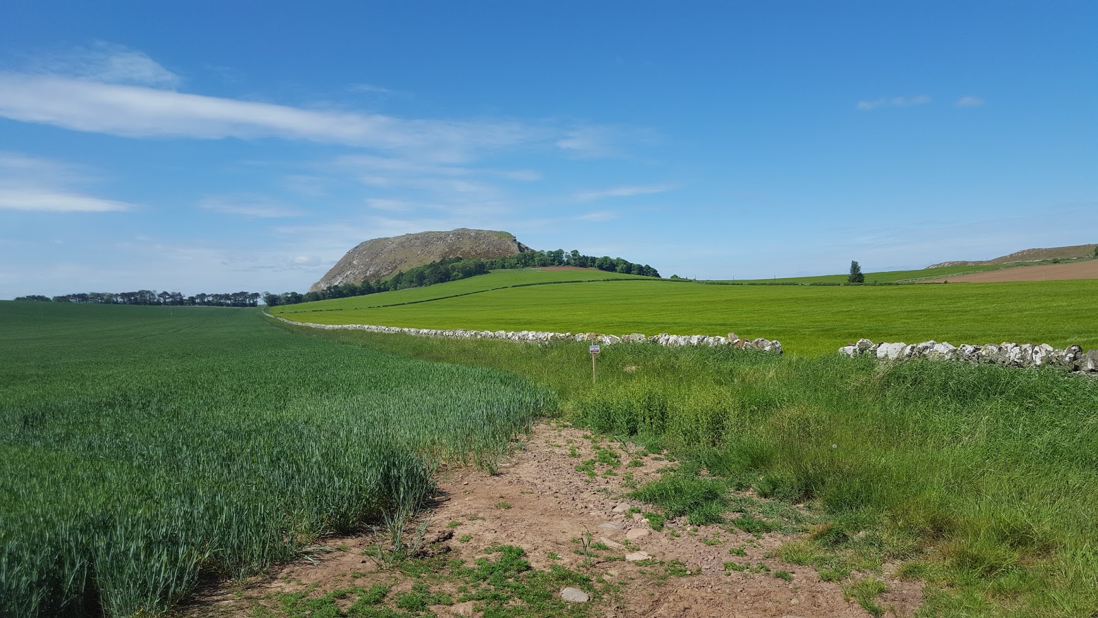
The hill certainly commands the surrounding area. Here is Ben on the path with Haddington and Byres Hill, the next hill on today's agenda, in the background.....
 
 
The trig and cairn looking north to the Bass Rock.....


and looking south to the Lammermuirs.....


north again with both North Berwick Law and the Bass Rock in the background.....


west to Haddington and the Hopetoun Monument with Arthurs Seat in Edinburgh back left; also the Firth of Forth and the Fife coast.....


There are stones in the shape of a ring fort close by the trig; this is looking over them to the Lammermuirs.....

A notice at the foot of the hill said that there was a herd of a dozen Exmoor ponies grazing the slopes but fortunately they must have been at the other side of the hill today so Ben was able to stay off the lead.
 
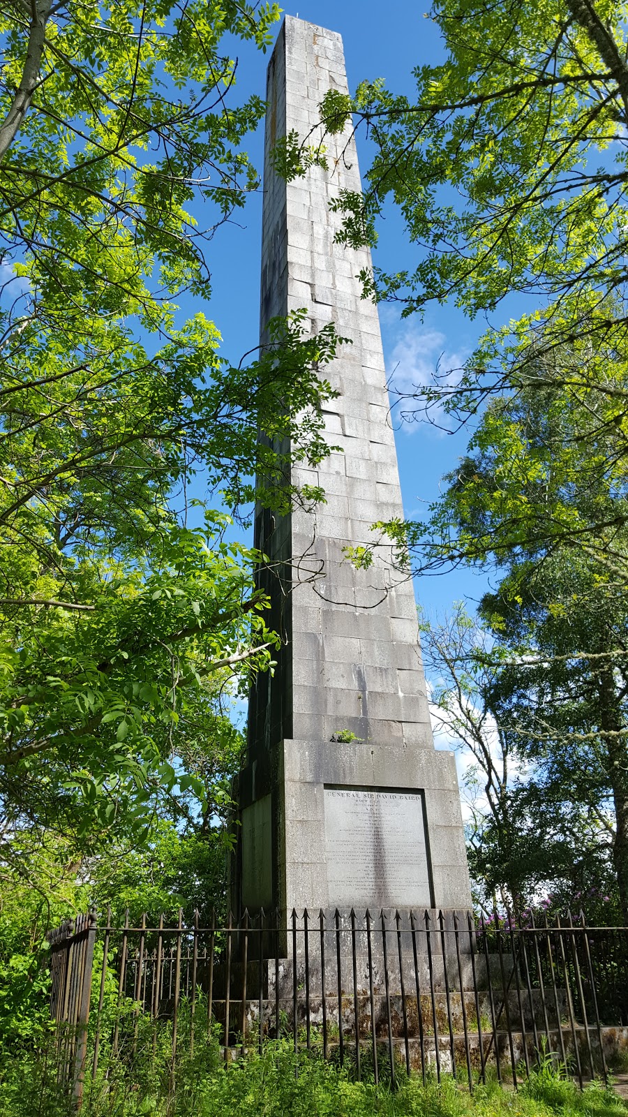
Back at the car we headed for the Hopetoun Monument but before doing so made a small diversion to have a look at Hailes castle. I had been here a few times before, it sits in a peaceful spot on the banks of the river Tyne. The castle dates back to the late 13th century and was extensively expanded over the next 200 years. It exchanged hands between the Scots and the English a number of times and was once owned by James Hepburn, 4th Earl of Bothwell, the third husband of Mary, Queen of Scots. I took a few photographs.....


The next objective was the Hopetoun Monument which stands at the top of Byres Hill to the north of Haddington and which can be seen for many miles around. Byres Hill is a Tump. The Monument is 95' tall, has 132 steps and was erected in 1824 to the memory of John Hope, 4th Earl of Hopetoun. There is a commemorative plaque.....
 
 
It reads "This Monument was erected to the memory of the great and good John, Fourth Earl of Hopetoun by his affectionate and grateful tenantry in East Lothian MDCCCXXIV". Changed days! There is a similar monument to the Earl across the Forth near Cupar on the top of Mount Hill but it is not nearly in such good condition.
 
Approaching Byres Hill from the west.....
 
 
There is a car park and information boards from where a path winds steeply up the hill.....
 
 
Ben at the tower and at the tower door.....


The view across the Forth to Fife.....
 
 
No high hills today but an interesting trip nonetheless.