29 October 2013
Participants: Just me
Where: Killyleoch Hill, 240m/786', Sub-2k Marilyn, Map 78, NX 878820
Killyleoch Hill only joined the ranks of Marilyns a few months ago. Not as a result of volcanic activity in Dumfries-shire but because it was found that inaccurate measurements had previously been taken at a col somewhere near at hand and the hill's relative height was in fact over 150 metres.
I had intended doing the hill sometime en route to or from the north of England but according to the weather forecasters, today was likely to be the only decent day for hill walking for quite some time. The dreaded Atlantic fronts were piling in to the country bringing heavy rain and strong winds. So it was a case of "seize the day" and I didn't regret it.
It turned out to be another of these hills that is really only high moorland, albeit covered in trees on it's east slopes. This is it viewed from the small village of Dunscore.....
There was space for one car in the bell end of the track to the farm at Newtonairds to the south of the hill. The track wound up through the trees before heading through a gate on to the open hillside. I went through a field containing cows, fortunately of the docile variety, out through another gate, then turned left through two more gates and into another field also containing cows, of the Highland variety this time. They were at the other side of the field and I managed to sneak past them without them noticing me. On the way back, however, they had moved to the part of the field containing the gate so, just to be sure, I kept to the other side of the wall, just inside the trees. The going was ok. For anyone thinking of doing the hill, this is a picture of gates 3 and 4 that you have to go through.....
At the top of the field, I crossed a wall into some rougher ground. A path was starting to form through the bracken and heather; maybe made by Marilyn baggers updating their lists? From this area, there was a good view across the valley to Bishop Forest Hill, which I climbed a couple of years ago.....
And there was also a view south to Criffel.....
Three more wall crossings followed and then the summit was in sight.....
It may not be very high but it is a smashing viewpoint. This is looking west.....
and east with Queensberry prominent.....
The foliage is really turning now, not many days left before the leaves are stripped from the trees, I guess. The colours seem to have been really strong this year. On the way down, I passed this tree, not sure what it is but it is certainly a striking colour.....
Tuesday, 29 October 2013
Saturday, 12 October 2013
Fionn Bhealach- my 700th Marilyn
11 October 2013
Participants: Neil and Ben
Where: Fionn Bhealach (Arran), 444m/1,456', Sub-2k Marilyn, Map 69, NR 977497
Participants: Neil and Ben
Where: Fionn Bhealach (Arran), 444m/1,456', Sub-2k Marilyn, Map 69, NR 977497
The choice for my 700th Marilyn as a day walk from home was a bit limited. I still have a few to do round about Lochgoilhead but there are problems with fences and I also didn't fancy another hill that involved a lot of walking through forestry. But I still have all of the smaller hills on Arran to do, the forecast was excellent, and Fionn Bhealach looked as though it would be a good viewpoint. So that was it chosen! The early morning cloud was breaking up as the ferry crossed the Firth; this is looking towards Goat Fell, Fionn Bhealach is the small bump on the right hand side of the picture. It is on the opposite side of Glen Chalmadale from the main hills and I was hoping for a good view of them from its summit.
It was certainly looking brighter to the west as the Caledonian Isles entered Brodick Bay.....
I had planned on starting the walk at Lochranza but as I drove down into the village it was obvious that there were lots of sheep on the slopes. I didn't fancy getting dragged up the hill on the end of a lead attached to a strong and enthusiastic spaniel. So I turned the car and drove back to the highest point of the road where there was a lay-by and where I had noticed that the hillside was devoid of sheep. You soon get into the way of looking out for those things when you have a canine companion! It certainly wasn't the best way up the hill but it was the shortest and I was delighted to see that there was a quad track heading up, which meant that I avoided the worst of the rough ground and wetness. Only problem was that the weather was looking a bit grey over this part of the Island. I stopped after a short distance to take this picture looking across the glen to Caisteal Abhail.....
and this one looking to the hills further west, above Catacol.....
There were no sheep but I spotted a stag further up the hillside. About half way up, a group of about 15 hinds ran across the higher reaches of the hill; Ben went on his lead until they were safely out of the way. The stags on the other side of the glen were in good voice and the one on our hillside expressed his view from time to time. Arran is a fantastic place to be to see and hear them in the rutting season.
The track continued more or less to the ridge and soon the trig came into view- a nice freshly painted job this one.....
Here is a picture of the trig and Ben with the Graham, Beinn Bharrain in the background.....
The weather was being obstinate; this side of the Island was clearly pulling in all of the cloud while everything to the west and north was getting brilliant sunshine. Still, I have had worse! This is looking across the Clyde over the southern tip of Bute to the Cumbrae's and the Ayrshire coast.....
the view to Caisteal Abhail.....
and to Beinn Bharrain.....
I had booked on the last ferry so that I could take time to see a bit of the Island. So I drove over to the west of the Island to find the sunshine. I discovered that there was a FC way-marked walk from just north of Blackwaterfoot that went over to the coast so I took a wander along that. The weather was indeed better here, you would hardly think that it was the same day and that the two areas were only about 10 miles apart as the crow flies. These are shots of Beinn Bharrain over Machrie Bay.....
and one taken looking down the Sound of Arran to the Mull of Kintyre.....
A good day and as I still have lots of hills to do on Arran, it is firmly in the diary again for next year.
Monday, 30 September 2013
Cnoc Reamhar- much effort for a little one
29 September 2013
Participants: Neil and Ben
Where: Cnoc Reamhar, 265m/870', Sub-2k Marilyn, Map 55, NR 766912
Cnoc Reamhar is one of the smallest sub-2k's that I have climbed this year but it probably took more effort than any other. There was no indication of what was to follow however when we left the car park at Crinan harbour. It was a really beautiful day, the area looking at its best.....
We followed a way-marked path which led along the shoreline then upwards through some birch trees to join a forest track. At a junction, signposted, we took the left hand branch. After a bit Cnoc Reamhar came into view.....
Just after that, a mishap occurred, my own fault. I was trying to do two things at once- walk along and read the map to see if there was any indication of a route through the massed ranks of conifers. So of course I tripped and landed full length. Ben thought this was a great game as I reorganised myself; apart from wrenched muscles or something in my arm I had got away with it. Cnoc Reamhar still seemed a long way away, and there was still no sign of the break in the forest that I knew was there.....
Eventually I came to a big cleared area to my right and the track ended. This time I stopped and sat down to look at the map. I had come way too far. So it was about turn and after about a mile I saw it, a rough track running into the trees. How I didn't spot it when I first passed it I don't know. It starts towards the bottom right in this picture.....
It turned out to be an old forestry track, probably put in when the forest was being planted and never used since. After a bit it started to run parallel to the ridge. After a few hundred yards of this, I decided that it was not going anywhere near an exit on to the hillside above so retraced my steps. Just before the track turned downhill again, I spied a possible break on my left. There was some fallen timber but above that it looked as though the break opened out a bit and headed for a notch in the ridge to the north of the summit. I decided to try it so up we went; it was not too bad going at all. Then, another obstacle. A fence, with barbed wire on top. I wasn't going to get Ben over this. Just when I was on the point of calling it a day, I found a ditch under the fence that probably contained a burn in the rainy season. There was just enough room for Ben to get through. Above, the hillside opened out and there was a view back down to the forest.....
It soon became clear why the fence was there. Cow pats! I hoped that the perpetrator's would be well down the other side of the hill, although there was plenty evidence to show that they wandered up to the top. It was a steep wee climb on to the ridge and- hooray- there was the trig- at last!
After all the travails, it turned out to be a great wee narrow ridge with superb views, although it was a bit hazy. Here is Ben at the trig.....
A view down to the forest with the track that we had walked in clearly visible.....
A view south to Loch Sween......
And a view to the Paps of Jura.....
I didn't hang about too long, the ridge was narrow with cliffs on one side and I didn't want Ben wandering off. On the way down, I suddenly spotted a bovine and more to the point, it spotted us. I didn't wait for it to summon up it's mates. Fortunately, although showing signs of wanting to investigate, Ben reacted to the command and we dropped into the gully, over/under the fence and into the safety of the forest.
How not to climb a hill, and take the best part of five hours doing it!
Saturday, 28 September 2013
Meall a'Bhuachaille and Ryvoan Bothy
24 September
Participants: Neil and Ben
Where: Meall a'Bhuachaille, 810m/2,657', Corbett, Map 36, NH 991115
Participants: Neil and Ben
Where: Meall a'Bhuachaille, 810m/2,657', Corbett, Map 36, NH 991115
I was heading home after my short trip and decided to cross the Cairngorms (by car of course!) and call in at Ryvoan bothy (Ruighe a'Bhothain or Shiel of the Bothy) for a look-see as it had been ages since I had been there and much work had recently been done to smarten it up. It is one of the most visited of the MBA bothies as the visitors book indicated but it was in great condition, thanks to the efforts of the Maintenance Officers. The building as it stands today is all that is left of a farm, a much bigger building that was abandoned in 1877. The bothy comprises a single room with a lean-to porch; it looks very small from the outside but is surprisingly roomy inside. There is even a sleeping platform! The MBA took on responsibility for its maintenance in 1972 and I remembered it as being pretty rough and ready on the previous occasions I had been there. Not now though.
It had been overcast as I was driving to Glenmore and I passed through really misty conditions just before Aviemore but the clouds were breaking up as I approached the bothy and by the time I had had a good look round the tops of the Munros were clear. The fine Corbett of Meall a'Bhuachaille overlooks the bothy and the path up starts at the bothy door. I didn't take much persuasion when Ben left the bothy and headed straight for the hill path! I have been up here many times but not for a few years. In the intervening period, considerable work has been done on the path. What used to be a rough, boulder and heather mixture of a path is now a motorway surface standard. There was a good view back down to the bothy from part way up.....
In no time at all we were approaching the large shelter cairn.....
However, a smaller cairn close by was the viewpoint for Loch Morlich.....
The cloud was floating around the tops of Bynack Mor and Cairngorm.....
It was good to be back in the 'gorms again even if it was only a fleeting visit on this occasion.
Thursday, 26 September 2013
Fourman Hill, Knockan, and ton up for Ben
23 September 2013
But it was a less striking looking hill that I was aiming for, Fourman Hill, a sub-2k north of Huntly.....
There was a cairn and trig situated inside a patch of gorse.....
The next hill that I had targeted was not so nice looking, really only an area of high moorland and now also spoiled by wind turbines. The starting point was a minor road between the A95 west of Keith and the B9115 to Dufftown. There was space to park at a cattle grid beside the start of the wind farm access road, which I simply followed up on to the plateau....
I hadn't, of course, taken the map with me not realising that the plateau would be so flat that the highest point would not be obvious. Doh!
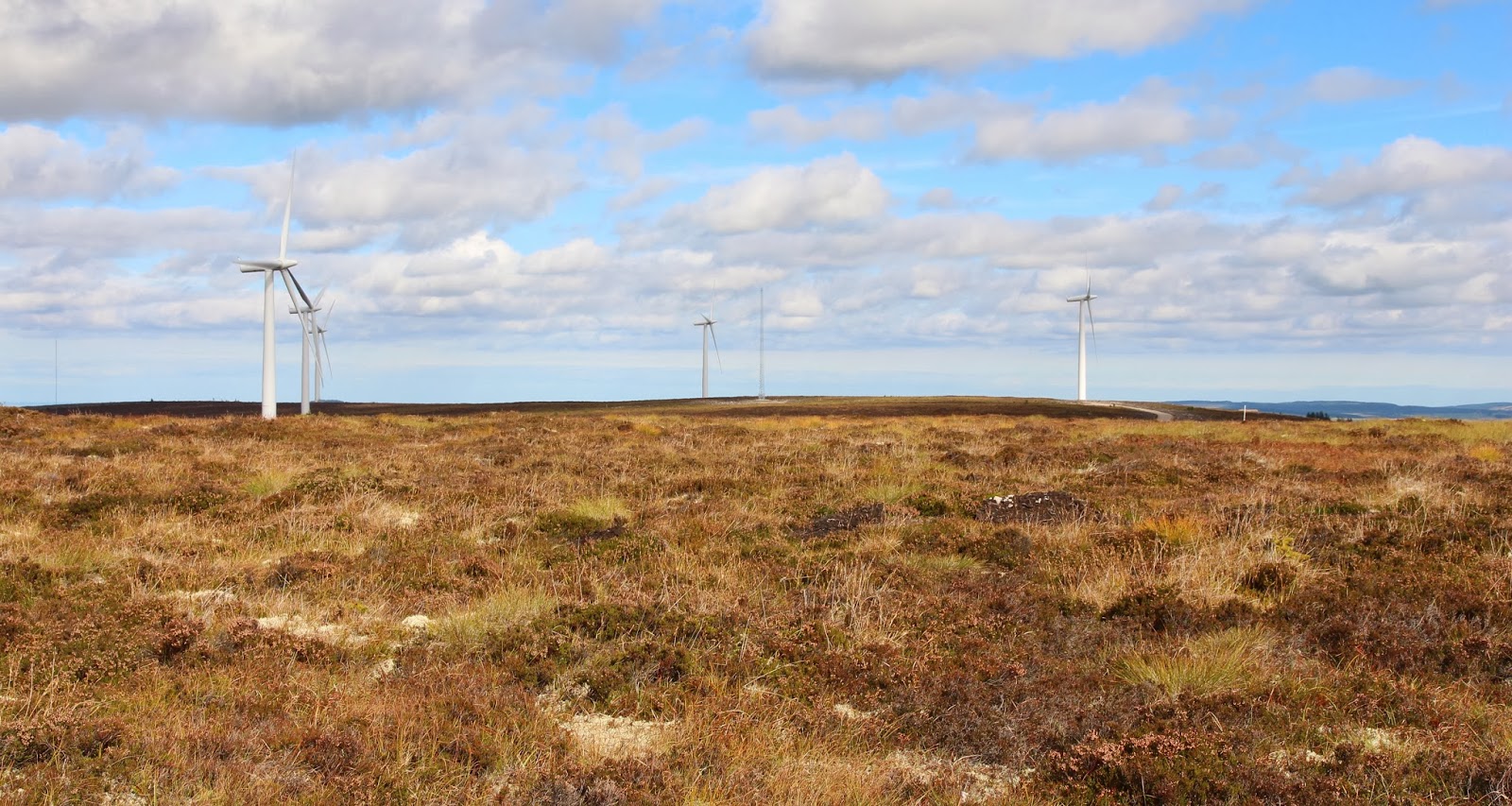
However, after a bit of searching a cairn was spotted. It was so flat up here that there wasn't much of a view although Ben Rinnes did make an appearance on the western horizon. I'm not certain that the cairn is the highest point, the ground immediately to it's north looks as though it might be a bit higher. For anyone else who ventures onto Knockan without a map the cairn is a couple of hundred yards north of turbine no.4.
And then it was back down the track to the car.....
I rounded off the day by visiting Balvenie Castle at Dufftown.....
This ruin is notable for housing at various times the Black Comyns, the Black Douglases and the Earls of Atholl. There is a connection to Robert the Bruce and Mary, Queen of Scots was a visitor. Although now looked after by the State, it is owned by an American. So does history unfold!
Participants: Neil and Ben
Where: Fourman Hill, 344m/1,128', Sub-2k Marilyn, Map 29, NJ 571458 and Knockan, 372m/1,220', Sub-2k Marilyn, Map 28, NJ 351463.
The forecast was correct, it was a cracking day. The colours on Ben Rinnes were amazing.....
But it was a less striking looking hill that I was aiming for, Fourman Hill, a sub-2k north of Huntly.....
It didn't matter that it was not very high, the view from any hill would have been worth the effort today. There was space for the car at the top of the minor road that branched off the A97 at the Bogrie hotel and continued uphill for about a mile past the farm at Fourmanhill. There wasn't going to be much ascent today to claim the sub-2k's; there was only about 100m worth of climbing from the car park to the top of Fourman Hill and about the same on Knockan later in the day. From the road, a track meandered gently up a pleasantly wooded area on to the open moor.....
There was a cairn and trig situated inside a patch of gorse.....
and there was a view, inevitably in this part of the country, to Ben Rinnes.....
Another small sub-2k, Knock Hill, was a few miles away to the north. I climbed this one a couple of years ago.....
I really like the contrast between the moorland and the farmland in the north-east; this is looking across Banffshire.....
The next hill that I had targeted was not so nice looking, really only an area of high moorland and now also spoiled by wind turbines. The starting point was a minor road between the A95 west of Keith and the B9115 to Dufftown. There was space to park at a cattle grid beside the start of the wind farm access road, which I simply followed up on to the plateau....
The angle of the "climb" can be seen in this photo.....
I hadn't, of course, taken the map with me not realising that the plateau would be so flat that the highest point would not be obvious. Doh!
However, after a bit of searching a cairn was spotted. It was so flat up here that there wasn't much of a view although Ben Rinnes did make an appearance on the western horizon. I'm not certain that the cairn is the highest point, the ground immediately to it's north looks as though it might be a bit higher. For anyone else who ventures onto Knockan without a map the cairn is a couple of hundred yards north of turbine no.4.
This was Ben's hundredth listed hill (Munro/Corbett/Graham/Sub-2k). He found a puddle to have a celebratory drink from.
And then it was back down the track to the car.....
I rounded off the day by visiting Balvenie Castle at Dufftown.....
This ruin is notable for housing at various times the Black Comyns, the Black Douglases and the Earls of Atholl. There is a connection to Robert the Bruce and Mary, Queen of Scots was a visitor. Although now looked after by the State, it is owned by an American. So does history unfold!
Subscribe to:
Posts (Atom)