27 April 2013
Participants - Just me
Where - Fell Hill, 417m/1,368', Sub-2k Marilyn, Map 77, NX 722 844 and Bogrie Hill, 432m/1,417', Sub-2k Marilyn, Map 78, NX 789859
The weather folk were saying that there was more fresh snow on the highland hills so I headed south. Down the M74, through the Dalveen Pass to Thornhill, on through Moniaive and a couple of miles down a country road and I was pulling up at the end of the track that led to the ruins of Fell farm and my first hill of the day. And the weather was excellent, giving deep colours and great visibility. Although I hadn't been in this neck of the woods before, I knew that the hill that I had been seeing in the distance since leaving Moniaive had to be Fell Hill- the large cairn on top was clearly visible. This is the hill from the start of the walk.....
and a view from further up the track.....
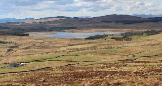
Spring had sprung at last. I saw a wheatear and heard curlews and skylarks. And on the drive home I saw my first swallows of the year. The track entered some trees and emerged at the old ruined farm. It must have been a lonely place to live. After passing the buildings it was on to the grassy hillside with good views back the way I had come. This is looking over the buildings, the trees and the track towards Loch Urr with my second target, Bogrie Hill, beyond......
It was a steady pull up and it wasn't too long till I saw the cairn ahead. It was a magnificent structure, about 10' high and the builders had thoughtfully built it so that there were stones sticking out low down to sit on.....
This is the view looking east towards Queensberry.....
and west into Galloway; the hill on the left is Cairnsmore of Fleet.....
Further away I could see some of the main Galloway hills around the Kells.....
It really was an excellent viewpoint. However, there was one potential blot on the horizon- I could see at least three of these wind test indicator masts that usually signal that a wind farm is planned. It looks as though Fell Hill and its surrounds could shortly be ruined, which would be a great shame. I don't mind the array of turbines down the side of the M74 but when they start to destroy areas like Fell then it becomes a bit much. I had a look at the website when I got home and sure enough, a 50 turbine wind farm is being scoped for the Loch Urr area. So climb these sub-2k's quick before building starts!
After a wee rest back at the car, I drove a few miles down another country road past Loch Urr and parked at the entrance to the road to the farm at Shillingland. About a hundred yards up the farm road a 4WD track headed up the hillside so I followed that- it went almost to the summit. Bogrie Hill was not such a distinctive hill as Fell Hill although I was surprised when looking at the map later to see that it was the higher of the two. There was a good view over Loch Urr to Fell Hill (right) from the route up.....
The Lowther Hills were in the background as I approached the trig.....
Cairnsmore of Carsphairn is in the background to this picture.....
And again in this one.....
A view to Criffel outside Dumfries with the Lake District hills faintly in the background.....
and another view to Cairnsmore of Fleet over Loch Urr.....
I took 2 hours 30 for Fell Hill and 1 hour 30 for Bogrie Hill. It was another nice piece of countryside; I hope that it's not spoiled in the name of renewable energy.


1 comment:
That's the drawback of being the windiest country in Europe I suppose Neil. Interesting that wind turbines usually go hand in hand with that other blot on the landscape, large scale mono culture tree plantations. Ever noticed they are like evil twins, always sharing the same table, sitting side by side?
Another legacy from the past that's a scenic eyesore yet they were allowed to cover vast areas of Scotland as well without much hindrance. Never seen a calendar or tourist photograph yet of the two of them together promoting the beauty of bonnie Scotland.
Why not? Two proud icons of our country that can be seen from almost every mountain area now.
Post a Comment