Sunday, 12 November 2017

Miscellaneous Tumps 2: Dunblane Roman Camps; Dunmallard Hill; Windrigg Hill; Quhytewoolen Hill; Stone Hill; Quinloch Muir Hill; Dechmont Law; Seafield Law; Gormyre Hill

19 September 2017. Neil and Ben. Dunblane Roman Camps, 114m/374', OS 57, NN 775 006.
 
No sign of any Romans but I could see why they would want to camp here. There was a commanding view from this, a park at the highest point in Dunblane. Pity the slopes are all covered in houses. The highest point seems to be the covered top of a water container. North to Ben Vorlich and Stuc a'Chroin and east to the Ochil Hills.....


6 October 2017. Just me. Dunmallard Hill, 240m/787', OS 90, NY 468 246
 
I had climbed the Marilyn, Grayrigg Forest in the morning and decided to drive to Pooley Bridge on the outskirts of the Lake District in the afternoon. Dunmallard Hill sits above the village.....
 
 
There was a view of Ullswater from the start and glimpses of the Mell Fells on the way up but otherwise the view was zilch. Nice woodland walk though.


7 October 2017. Just me. Windrigg Hill, 313m/1027', OS 91, NY 583 177

I was passing time before going to the MBA AGM at Langwathby in Cumbria. There was minimal ascent across a field from the road. The trig was hiding behind a wall; the highest point seemed to be on the other side at a covered water tank.


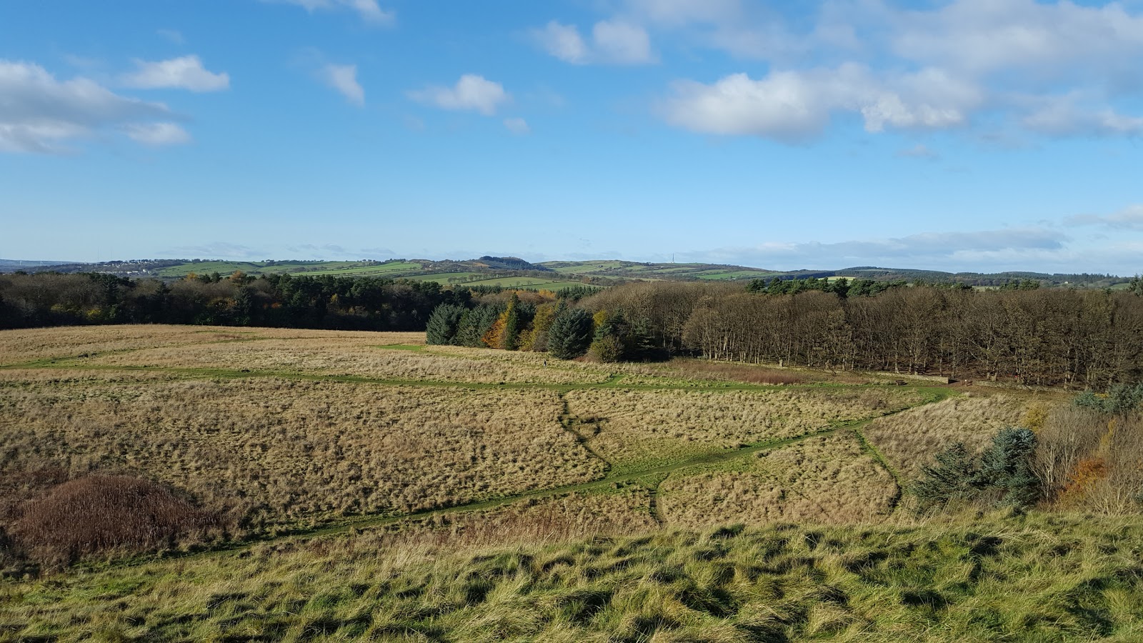
8 October 2017. Just me. Quhytewoolen Hill, 223m/732', OS 78, NY 148 831
 
On the way home from Langwathby. It was the name that attracted me to this hill above Lockerbie. I parked at the end of a track to the east and walked up past an old hill fort. There was a fine view from the top.


26 October 2017. Neil and Ben. Stone Hill, 274m/899', OS 57, NS 814 997
 
Stone Hill is a western outlier of the Ochil Hills, reached easily from the Sheriffmuir road. A mixture of heather and grass, there is a large stone at the high point- guess that this is how the hill got its name?


There was a fine view of  Dumyat from the lower slopes- the foliage is falling fast now.....


29 October 2017. Just me. Quinloch Muir Hill, 221m/725', OS 64, NS 516 810

This is a Tump east of the A809 opposite Auchineden Hill. The quick ascent is from the car park for the latter- cross the road, climb over the wall, walk through some boggy ground and you're there. There are 3 tops, the southern one is the highest (on the right in this photo).....


There was a good view of the west Campsie Fells.....


The lower northern top is the best for the view to the highland hills, Ben Lomond is prominent in this shot.....


12 November 2017. Neil and Ben. Three in West Lothian, Dechmont Law, 217m/712', OS 65, NT 034 698; Seafield Law, 198m/651', NT 004 667; and Gormyre Hill, 236/774', NS 976 727.

I hadn't realised that there was hill in Livingstone, especially one that was a viewpoint comparable with many a higher hill. There was a car park at the east side of Deans Community High School and good paths round and up to the trig. It was a popular dog walking area. Some views, of the Pentland Hills.....


to Bathgate and Cairnpapple Hill.....


to the Forth bridges......


It was a bit of 'from the sublime to the ridiculous' next- Seafield Law, which many years ago was a bing although it looks like a "normal" hill now. The local authority are doing their best to improve this area with loads of cycle paths and a nature reserve beside the hill. Not a bad view either, Ben at the top with the Pentland hills beyond.....


For the final hill of this short day's outing, I headed for Torphichan and Gormyre Hill. I'm not sure what the local farmer is trying to keep out, or in, but he has a liking for barbed wire fences. Not the most impressive hill in the area. Looking to Cockleroy.....


and to the sweep of the Ochil hills and the hills of the southern Highlands, the latter with a dusting of snow.


Friday, 3 November 2017

In the shadow of Ben Vrackie

2 November 2017

Participants: Neil and Ben
Where: Creag Bhreac, 557m/1827', Tump, OS 43, NN 949618, Meall na h-Aodainn, 633m/2077', Hump, NN 942 622, and Meall Uaine, 626m/2054', Tump, NN 937 618
 
What a glorious late autumn day- hardly a cloud in the sky and superb visibility. I had climbed Ben Vrackie on numerous occasions but had not ventured on to the ring of smaller hills that lay between it and Pitlochry. They had built a second car park just past Moulin since my last visit and just as well- it was almost full when I arrived. Lots of people on the hill- on the one hill, Ben Vrackie, as I saw no one on the tops that I was on. The path to the hill had been improved as well. First sight of the hills after emerging from the trees, Creag Bhreac with Ben Vrackie beyond.....
 
 
and Meall Uaine and Meall na h-Aodainn.....
 
 
I followed the path to almost its highest point before striking off up rough ground to Creag Bhreac from where there was a great view of Ben Vrackie.....
 
 
View to Meall Uaine from summit.....
 
 
and to Meall na h-Aodainn.....
 
 
and a panorama of all three.....
 
 
I dropped back down to the path and carried on to Loch a'Choire at the foot of Ben Vrackie.....
 
 
The path along the lochside was a bit muddy and on the sheltered side of Meall na h-Aodainn there were traces of ice in places, winter is coming. A view of Ben Vrackie from the path, I could se a crowd of people on top.....
 
 
A shortish climb through the heather brought me to the well defined top of Meall na h-Aodainn, a fine viewpoint. The distinctive cone of Schiehallion with the Blackmount hills visible behind it, the route of the A9 and the village of Blair Atholl.....
 
 
Beinn Dearg (Atholl), a fairly remote Munro.....
 
 
And then Ben disappeared. The sun was in my eyes and I didn't see him go but there were deer about and he must have chased off after them. I didn't know which direction he'd gone and after about 10 minutes shouting I was becoming concerned. He usually comes back to the point at which he left me so I started to retrace my steps although I wasn't certain of the exact route that we'd come. And then he appeared, climbing slowly back up through the heather, goodness knows how far down the hill he'd chased the deer. We were both relieved to be reunited and he stuck close to me for the rest of the walk.
 
I re-joined the path and followed it downhill for a bit before taking to the steep slopes of Meall Uaine. The heather was challenging! Although it was a fairly short climb I wondered a couple of times if it was worth bothering about this hill but we stuck at it. Thank goodness we did, it was the best viewpoint of the day. How's this for a photo of Loch Tummel and Schiehallion.....
 
 
The tops of the Beinn a'Ghlo group could just be seen, east of the Glen Tilt hills.....
 
 
Ben was tired (and so was I)......
 
 
The highest point on this hill has apparently varied over the years from where I was to the next bump along the ridge but thankfully today it was the first top we came to- the one with the small receiving mast.
 
Another view of Ben Vrackie on the way down.....
 
 
and of Creag Bhreac from near to the main path.....
 
 
It was a tough but satisfying round. Most folk doing it would also include Ben Vrackie but that is beyond me nowadays. Still, if Humps and Tumps can produce these views then I don't need to do more repeats of the higher hills.


Monday, 16 October 2017

Grayrigg Forest

6 October 2017.

Participants: Just me
Where: Grayrigg Forest, 494m/1,621', Sub-2k Marilyn, OS 97, SD 599 998

This is a fine looking hill when seen from the M6 travelling south from Penrith.....


I approached it from the junction of the A685 and the B6257 parking in a lay-by at the side of a rifle range.....

It was a completely grassy ascent, steeply at first to Grayrigg Pike but once on the ridge the views opened out. I was accompanied on the walk by the sound of motorway traffic.....


After the Pike, the hill got broader and I could see the summit trig in the distance.....


It was a fine summit to sit down for a while and admire the views, the southern Lake District hills to the north.....


the Howgills to the south (must go there one day).....


and a view over Kendal out to sea as well.....


A fine Marilyn and a pleasant walk, easily accomplished in under 3 hours car to car.

Friday, 13 October 2017

Blaze Fell and Beacon Hill

5 October 2017.

Participants: Just me.
Where: Blaze Fell, 242m/794', Hump, OS 86, NY 496 433 and Beacon Hill, 286m/938', Hump, OS 90, NY 521 314

I was in Penrith for the MBA AGM at nearby Langwathby and decided to climb these two Humps on the way down. Blaze Fell turned out to be a nice hill reached by a permissive path from it's east side.....


The summit area was access land and was the site of an old quarry.....


Being situated between the Lake District and the Pennines it was an ideal view point for both. This is looking to Blencathra and other northern Lakeland hills.....


and on the way back down I was looking towards the northern Pennines.....


Beacon Hill stands above Penrith, here seen from the ruins of the castle.....


I parked in Beacon Edge which accounted for a lot of the ascent. The hill is heavily wooded so there wasn't a view; it was again the case of the wrong time of year to visit.....


The monument on top was built in 1719 on the spot where beacons have been lit since the time of Henry VIII......


There was also a topograph which seemed to me to be a bit optimistic, given that the foliage obscured all the views!


Monday, 9 October 2017

Edinburgh City Hills (Part 1): Corstorphine Hill and Calton Hill

Edinburgh is said to be built on seven hills but as the city has expanded, this is becoming rather an out of date statement. For hill bagging purposes, there are 10 major hills listed as either Humps or Tumps plus a few other smaller hills around the City boundaries. I stayed in Edinburgh for 30-odd years and in all that time only climbed two- Arthur's Seat and Calton Hill. It was long past time to visit them all.
 
30 September 2017. Participants- just me. Corstorphine Hill, 162m/531', Hump, OS 66, NT 206 741
 
I got the train through to Edinburgh- delayed due to work on the line, got as far as Linlithgow and had to get a bus from there. Great advert for public transport! Still, I wasn't in any hurry. Corstorphine Hill promised to be the hill with the poorest view so I decided to start my Edinburgh quest with it. I walked from Corstorphine Road so it felt like I was climbing a real hill in height terms. The most interesting feature was Clermiston tower, situated near to a transmitter mast. It is a 20m tall tower built in 1871 by local landowner William McFie to celebrate the centenary of the birth of Sir Walter Scott. Unfortunately, it is only open to the public occasionally and this was not one of these days so I was unable to get above the thick foliage that covers this hill in order to get a view. There are a couple of points close to the tower which could be the highest point of the hill. My photos:


I then got the bus to the east end of Queen Street for another visit to Calton Hill, one of the City landmarks.
 
30 September 2017. Participants- just me. Calton Hill, 101m/331', Tump, OS 66, NT 263 741
 
I got a pleasant surprise- I didn't know that the Nelson Monument was open to the public. I reckoned that a £5 admission fee would be worth it for the panoramic view from the top- it most certainly was- and there was also an interesting exhibition.
 
 
The monument was built in order to express gratitude to Admiral Lord Nelson for his victory in the Battle of Trafalgar and in which many Scots took part. The design is said to represent an upturned telescope. Building work began in 1806 and was completed in in 1816.
 
As well as commemorating Nelson, the monument became a naval signalling station soon after it was completed. In 1852, a time ball was installed at the top of the monument, designed to drop at precisely one o'clock every day thereby sending a signal to ships in the Firth of Forth. In those days it was critical to know the correct time to enable ships to calculate their position. The signal couldn't be seen in bad weather so in 1861 a sound signal was added- the firing of the one o'clock gun from the ramparts of Edinburgh castle. Both these events continue to this day.
 
Here are some of my photos taken from the viewing platform.
 
Looking along Princes Street with the headquarters of the Scottish Government, St Andrews House, the building closest (left) and the Castle beyond....
 
 
Edinburgh Castle with the Pentland hills distant.....
 
 
The south side with the Pentlands distant.....
 
 
Three more of the hills, Dunsapie, Arthur's Seat, and Salisbury Crags.....
 
 
Palace of Holyrood House, Scottish Parliament and the East Lothian coast.....
 
 
The "Greek" folly built to resemble the Parthenon in Athens but never finished, Leith with Hibs football ground prominent and the east Lothian coast with North Berwick Law visible.....
 
 
The Firth of Forth and the bridges.....
 
 
The redevelopment of St James square (a former office of mine is just a pile of rubble) with Corstorphine Hill distant.....
 
 
Back at ground level, the folly.....
 
 
Oh, and the highest point of the hill is a rock beside the foot of the monument.
 
So a good start to the Edinburgh hills. I aim to do the rest of them over the coming months.