Friday, 9 September 2011

Craigowl

8 September 2011

Participants - Us again
Where - Craigowl, 455m/1,492', Sub-2,000' Marilyn, Map 54, NO 377400

My earliest recollection of going to the hills was a school trip to the Sidlaws when I stayed in Dundee. I can't remember if we got to the top of anything or not but the trip must have had an effect on me because I have since developed a life long addiction to the hills. Craigowl is the highest in the range and I had passed it many times heading up the Dundee to Forfar road to Glen Esk and such places before I eventually got round to climbing it.....


So this was my second visit on a day when the weather just got better and better. I parked at the Balkello Community Woodland car park near to Auchterhouse. There were lots of paths and I chose one that seemed to be headed in the general direction of Auchterhouse Hill, the most westerly of the three tops that we aimed to climb. After leaving the woodland, we joined a path that headed up a wee glen between Auchterhouse Hill and Balluderon Hill. This is Auchterhouse Hill.....


and this is the type of scenery we were walking through.....


We came across the occasional fence, usually there was a gate and where there wasn't the fence was old enough to let Ben slip through without difficulty. It didn't take long till we were approaching the memorial to Syd Scroggie that has been erected on the top of Balluderon Hill. Syd was a legendary local mountaineer and poet- a real man of the hills. Shortly after the end of World War II, he stepped on a land mine as a result of which he was blinded and lost much of one leg. However that didn't stop him going to the hills and his obvious enjoyment of his trips shines through in his poetry. A real inspiration!


The memorial could not have been erected in a better place; I would say that the top of Balluderon hill is by a long way the finest view point in the group. The memorial incorporates a view indicator giving the distance of some of the more prominent hills. Definitely a place to linger! This is the view looking across the Tay to the Lomond hills....


But I had an impatient spaniel with me and Craigowl was now in view ahead.....


The views now included Strathmore and the Grampians.....


We passed a lone pine on the way up Craigowl.....


which is unfortunately crowned by lots of telecommunications equipment. The trig was situated on a small mound between the buildings and there was also a small cairn a few yards away. I took this picture looking north-west to some of the higher hills; you can spot Schiehallion if you look closely.....


Dundee was much closer.....


We could have descended by another path directly back to the car park but it was a day for staying high so it was back the same way and another stop at the top of Balluderon Hill. Rather than head back to Perth by the main dual carriageway, I decided on the scenic route and headed up to Meigle. I had a suspicion that there might be a coffee shop there and there was- a really good place at the road junction in the centre of the village. It was warm enough to sit outside. I must be getting old.....when once I would have used every last ounce of daylight to tick off Munros I am now taking leisurely strolls over smaller hills followed by visits to coffee shops....hmmmmm

Sunday, 4 September 2011

Broughton Heights

4 September 2011.

Participants - Us
Where - Broughton Heights, 571m/1,874', Sub-2,000' Marilyn, Map 72, NT 122411

At last, a bright and sunny day, although the forecast said that cloud would spread in late afternoon. The only other time I have climbed Broughton Heights, it was a dull day and the cloud came down on the summit and I didn't get a view, so I had very few photographs of this area. So a good chance to rectify that today. There is a good walkers car park at Broughton Place, up a narrow road cum track from the village which saves about a mile in each direction. I was late setting off and didn't really expect to find a place in the car park but there were lots- everyone must have been away climbing higher hills. This is a beautiful wee glen, even more so today with the heather in full bloom. The area is also walker friendly and the route initially follows the John Buchan Way which runs from Broughton to Peebles......


The path followed the burn with Broomy Side, the most westerly of the Broughton Heights tops, ahead.....


It rose gently to a junction of paths at the Hammer Head pass- wonder how that got its name- from where there was a good view of the most southern 2,000' Marilyn of the group, Penvalla, best approached from Stobo.....


There were a lot of sheep about but as we started to ascend more steeply, we left them behind and Ben got off his lead. Maybe I'm just noticing these things now that I have a dog but there seem to be a lot more sheep about than there were even a couple of years ago. Anyway, we were now off the route of the Way and the path was much narrower as we headed up to the col between Clover Law and Broomy Side. We reached a fence but it had gaps in it and Ben had no problems; there was a style for me to cross. From there, it was a grassy hill path over a couple of subsidiary tops on a very pleasant narrowish ridge.....


and Ben as usual was first at the trig.....


It was a really fine viewpoint. This is looking east to the Pentlands.....


South were the hills above the Manor valley.....


and furher round, Broad Law.....


Approaching the summit, I saw something new that might have attracted Ben's interest, hang gliders.....


but he seemed to be more interested in an old sheep bone which got carried a fair way down the ridge on our return. He was so interested in the bone that he missed the fine view of Tinto in the distance.....


The border hills generally are quiet and I find that the Broughton Hills are especially so. But it is a fine bit of country and I will be back; I didn't get much of a day on Trahenna Hill when I climbed it the first time either. I could have added it on today but it was starting to cloud over when I got back to Hammerhead so I decided to leave it. At least that's my excuse!

Tuesday, 23 August 2011

Creag nan Gabhar

22 August 2011

Participants - Neil and Ben
Where - Creag nan Gabhar, 834m/2,736', Corbett, Map 43, NO 154841, time taken, 3 hours and 45 minutes

According to the forecast, this was going to be the best day of the week so off we went again, this time heading north to get in a highland hill before the deer stalking season started in earnest. Carn nan Gabhar rises steeply from Glenshee; it can be approached from the south using a path that goes over to Lochcallater Lodge. I've done this route once- it is the short way up but I think that that is its only merit. The route is shut in for most of the way, the hillside is rough and there is a boggy area just before the final rise to the summit. I much prefer the route from the north from the car park opposite Auchallater farm and that's the way that we went today. The parking area had been improved since my last visit and there is now a fee of £2.50 which a sign said went to path upkeep; however, the machine was not working today!

There was a good view of the hill from the main track, the summit, as is usually the case, is at the furthest away point.....


and from around the same spot, there was a view of the Munro, Carn an Tuirc to the south.....


We left the main Glen Callater track after about a mile to take another track that zig-zaggged up Sron Dubh, the northern top of the Corbett. This actually continued well up the ridge, turned into a path higher up and continued to the summit. It would be difficult to get lost on this hill! It was really easy walking over dry ground with some stones higher up.....


You really are in the middle of the hills here- Munros and Corbetts are all around- and there is nothing like a good ridge walk to take in all the views. And this is a good ridge walk. This is looking back down the ridge from near the top with two of the Cairngorm 4,000'ers- Beinn a' Bhuird and Beinn Avon on the horizon.....


There were a few cairns at the top, the biggest of these appeared to be the true summit. This is it with the Cairnwell Munros in the background.....


and another look to Beinn a'Bhuird and Beinn Avon......


and down to Loch Callater with the lodge and the bothy at its west end and the Lochnagar hills beyond....


It was a pity that the sky was cloudy but at least the summits were clear! I now had a choice, go back the way we had come or drop down to the bothy and walk back along the main track in Glen Callater. There seemed to be a lot of estate activity down at the lodge and a few vehicles on the track- no doubt preparations were in full swing for the shooting season which apparently starts on 1 September in this area. So I decided that it was a day to stay high and we went back the same way. The estate workers were out replenishing the grit boxes for the grouse and I watched this ATV for a bit. It seems to be able to cope with all sorts of rough ground, something to save up for when I'm too old to get up a hill under my own steam maybe!


There were certainly a lot of grouse about and I don't remember seeing the stone shooting shelters on the hillside the last time that I was here either. Back down the hill, Ben went for a dip in the Callater Burn......


I preferred a dip into the Cairnwell cafe before the main drive home!

Tuesday, 16 August 2011

Minch Moor

15 August 2011

Where - Minch Moor, 567m/1,859', Sub-2,000' Marilyn, Map 73, NT 359330
Participants - Neil and Ben

It was back to the border hills today for a walk along the Minchmoor road which is part of the Southern Upland Way, and a visit to the hill of the same name. I have done this a couple of times before; it is a pleasant, easy walk with fine views once the forestry section is left behind. As usual, I left the car in the car park at Traquair village hall which is just off the Way. Initially, after a short forest section, the track passes between fields and the hill comes into view for the first time- it is between the two forest areas in this picture.....


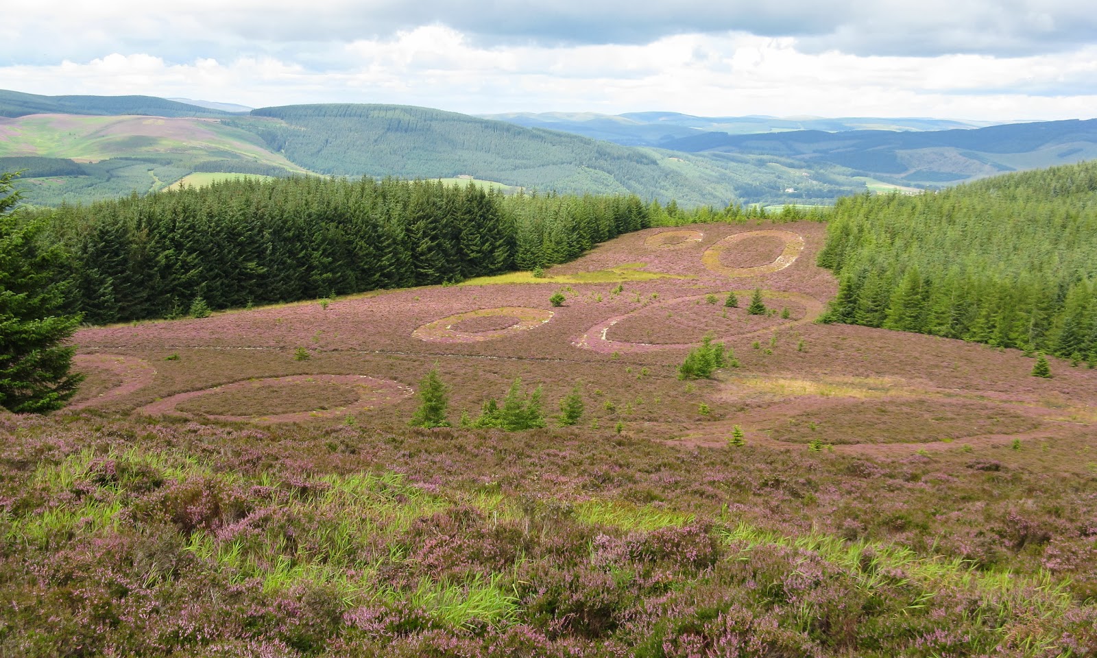
The route was full of interest. The first thing of note was modern- an unusual environmental scheme/sculpture down to the left of the track (heading east).....


There was an information board that explained what it was all about.....


I don't really get a lot of the modern sculptures- for example, the giant figure outside Cumbernauld seems completely pointless and a waste of money but small projects like this one especially if they build in another theme such as the environment I find interesting. But maybe in hundreds of years time they will attract the same level of interest as do the buildings and legends of our past. And shortly after the sculpture we stopped to have a look at one of these.

The Minchmoor road is an ancient drove road that was frequented by bandits  in days gone by. Nearing the first high point of the track, there is a spring named the Cheese Well, marked by a couple of inscribed stones. Apparently if someone passing it left an offering, usually cheese, for the fairies who were supposed to haunt the area then this would ensure a safe and successful journey. Here is Ben unsuccessfully looking for some cheese at one of the two stones that mark the spring.....


So no cheese, but plenty people obviously believe the legend and leave a modern offering- a coin- instead.....


Not long after passing the well, we reached a signpost pointing up a side track to the summit of the Minch Moor. Unfortunately, the early sunshine had faded, and the rain came on just as we reached the cairn. It was a short lived shower however so I hung around for the blue sky and sunshine to come back in order to take the obligatory summit photo.....


That was the last rain of the day, the sun came out again and the walk back was excellent with great views of the Dun Rig hills ahead and, when lower down, a view looking west along the Tweed valley.....


Sunday, 14 August 2011

Innerdouny Hill

14 August 2011.

Participants - Neil and Ben
Where - Innerdouny Hill, 497m/1,630', Sub-2,000' Marilyn, Map 58, NS 687918

I hadn't planned on going walking today but the weather turned out better than was forecast. So having decided to go, the next question was where? I am fast running out of local-ish Marilyns that are suitable for Ben and that I have not blogged; the fact that the forecast was much better for the east of the country narrowed the choice even further. In the event, I opted for Innerdouny Hill, the most eastern of the Marilyns in the Ochil hills. I had done it before and it provided a nice short day mostly on a forest track which was an advantage after all the recent rain. Although the map shows the hill covered in trees, the actual summit area is in fact clear and there is no problem getting to the top and there is a bit of a view.

I drove through the Hillfoot villages and took the Dunning road at Yetts o'Muckhart. There was space for a few cars at the entrance to the forest at Littlerig; mine was the only one parked there today so it looked like we would have the hill to ourselves. There was a lot of forestry work taking place in the lower reaches of the forest; you can see the summit that we were aiming for peaking out above the trees in the following two pictures.....


 Like a number of these forested hills, the track sloped gently up across the hillside so that you actually approach the top from the opposite direction that you started from. The first part of the forest had been cleared but higher up it remained as I remembered it....


At the highest point of the track just before it started to go downhill again, there was a good gap in the trees; the ground wasn't too rough and there were traces of a path.....


We crossed an old wall (a few stones were missing so no problem for Ben) and just beyond that could see the trig.....


The cloud had been building up and an obvious shower passed to the south but it remained dry for us. There was a reasonable view from here to Loch Leven and the Lomond hills.....


The sun came out again on the way back, this is looking to the hills on the other side of Glen Devon including Ben Cleuch (distance right). There are lots of wind turbines in the Ochil hills now, together with the forestry this is getting to be quite an industrialised landscape.....


By the time we got back to the lower reaches of the track, it was a perfect summers day.....


We enjoyed our 5 mile walk.

Tuesday, 9 August 2011

Meall a'Mhuic

9 August 2011.

Where - Meall a'Mhuic, 745m/2,444', Graham, Map 51, NN 579508
Participants - Neil and Ben

The weather forecast for the rest of the week was dire so it was today or not at all if I wanted a walk this week. I climbed Meall a'Mhuic a couple of years ago and enjoyed it and as far as I could remember there were no fences to cross or sheep to worry about so Ben would be able to run about freely. The Meggernie Estate seem to be particularly walker friendly and have provided a good car park with picnic benches and toilet facilities at Innerwick in Glen Lyon, the start of the walk. Here is a view of the hill that I took from close to the car park last time that I was here; all the other photographs were taken today.....


There are a lot of tracks hereabouts including an old one that zig zags up the hill to about the 530m height so its easy going. Just about where the track ends there are faint traces of some old shielings; this one certainly had a view! The jaggy ridge in the distance is Meall nam Tarmachan.....


There was a lot of short cropped heather higher up and it was really only a gradual slope and the cairn soon came into view. Here's an unusual picture- Ben not moving! The Alder group of hills are in the background.....


Looking further round to the east I could make out the hills at Drumochter with Loch Rannoch closer at hand.....


Schiehallion is always visible from around here.....


and the Corbett of Beinn Dearg and the Munro of Carn Gorm, the most westerly of the 4 Munros on the north side of Glen Lyon, were quite close. However, what you can't see is the glen of the Lairig Ghallabhaich between the hill that we were on and Beinn Dearg and as my days of belting on to get as many ticks in a day as possible are now over- I'm older and wiser as well as being more decrepit- I didn't bother......


This must be one of the few hills from where you can see all 7 Munros of the Lawers group.....


So after a rest at the cairn it was back the same way with the pleasant knowledge that there is an excellent tea room just a mile into the journey home. I couldn't resist.