Participants: Just me
Where: Stroness Hill, 352m/1151', P 76m, TuMP, OS 58,. NN 913262 and Stroness Hill North, 351m/1,151', P 48m, TuMP, OS 58, NN 921 271
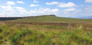
These two hills run east from the Knock of Crieff and Milquanzie Hill and although a TuMP compared to the other two's Marilyn and HuMP status, Stroness Hill is the highest of the range. The maps of this area are not up to date and there are many more tracks than shown including one that leaves the A822 about 1/4 mile past the Foulford golf course and which goes past the foot of Stroness Hill. There is also ample parking at the start. So that was the one that I took. The view of Stroness Hill North (centre) from the start.....
Looking to Milquanzie Hill from the track.....
These are rounded, grassy hills, given over to sheep. There was a good ATV track up Stroness Hill which eased the ascent and it didn't take too long to reach the top, unmarked. The wood shown on the map has now gone. Looking east to the North top.....
These hills sit just south of the Highland Boundary and provide a good view into the Sma' Glen area.....
The track continued on to pass just south of the highest point of the North top. The highest point was again unmarked but could have been at either of some boulders. Another view into the Sma' Glen.....
It was easier sticking to the path rather than descending through vegetation that was now growing tall and thick so I returned by the same route. Looking to Stroness Hill from Stroness Hill North.....
A very pleasant walk.


No comments:
Post a Comment