24 February 2016
Participants: Just me
Where: Bengairn, 391m/1283', Sub2k Marilyn, Map 84, NX 770545
The weather wasn't so good today. There had been a light fall of snow overnight and although clear, the skies were cloudy.
The start point was a side road to Collin, off the A711. There was a sign marking the start, and space to park a couple of cars, although as the verges were so soft, you might not have got a second car out again.
It was however a good solid track through the forest, but after that section, was as wet and muddy as I have come across in many a day. This area suffered badly in the rain storms of December and January although I suspect that this is always a wet hill. After leaving the track, the route was through a couple of fields; this is the view south to the Solway Firth from there.....
Bengairn was now fully in view.....
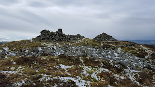
I made my way across a tussock ridden, reedy, area to the foot of an obvious gully where the going became better as I gained height. It was quite steep in places but brought me out about 50 yards from the top. There were a couple of substantial cairns.....
Unfortunately, the cloud hadn't lifted so the expected views weren't there. This is looking to the coast.....
and this is looking west to the Galloway hills, where it was obviously raining/snowing.....
In fact, it started snowing slightly while I was at the top so I didn't hang about too long. I simply followed the upward route back down again and, looking back, could see that a fairly heavy shower had set in.....
I stopped for a chat with the shepherd who was gathering in his sheep for vaccination. He said that he was missing 15 and was setting off to look for them in the direction of Screel Hill. Despite the weather and the wetness underfoot, I enjoyed the walk- 3 hours and 10 minutes car to car.


No comments:
Post a Comment