18 November 2012
Participants - Neil, Steven and Ben
Where - Tosson Hill, 440m/1,444', Sub-2k Marilyn, Map 81, NZ 004982
The dying days of autumn so we headed south to catch the last of the colour on the foliage (and add a new sub-2k Marilyn to the list of course!). I was really taken with Northumberland when I visited for the first time earlier in the year, it is so close to Scotland yet entirely different- quaint villages, the different use of stone in buildings, and of course the dialect. It deserves more of a visit than a weekend comprised of short days at the fag end of the year. We were staying at Rothbury which is at the foot of the Simonside Hills and the object on this occasion was Tosson Hill, the highest point in the range.
I drove up some narrow country roads through the hamlet of Great Tosson to a large Forestry Commission car park and picnic area at Simonside forest. It had been frosty overnight and it was a glorious day although the forecast was for more rain and wind to come in later. Although a lot of the foliage had fallen from the trees, the colours were still really strong and emphasised by the deep blue of the sky. The route followed good forest tracks initially; out of the car park past an information board and through a one-barred gate and then gently uphill until opposite a radio mast where we turned left. This is shortly after we left the car.....
At the next junction we turned right; the track rose uphill at the side of the forest and there was a good view back to Rothbury.....
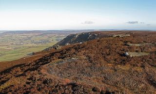
The map that I had printed off the internet suggested that our track should still be deep in the forest but in fact it was just outside. However it was obvious that we were heading for the foot of Simonside crag which was where we wanted to be. But when we got there confusion took over for a few minutes. The other bit of the forest that was marked on the map had been felled and it wasn't immediately obvious where the path that led up on to the moors actually was. After one false start we found it; it wasn't in particularly great condition but it led to where we thought that we wanted to be. As we got higher the views started to open out, this is looking east over Coquetdale and the village of Thropton and the second picture is looking north to the Cheviot.....
We reached a fence and a gate and I took another picture looking north to the Cheviot.....
At this point all doubts that we were on the right hill disappeared, we could see a large cairn in the distance across the moorland. The path, still very muddy, ran along the top of Ravens Heugh, another area of cliffs. This is looking back at it from closer to the cairn.....
And then we were there.....
The cloud was already starting to build in the west and there was a fairly brisk, cold wind blowing so we didn't linger for long before setting off back the way we had come.....
This is obviously a very popular walking area; there were lots of people on Simonside and the ridge to Dove Crag but no one else seemed interested in Tosson Hill. Simonside looked a great walk and if I was coming here again I would do that walk and not bother about the Marilyn. Although it was November and I expected that the moorland would be wet I guess that up on the fairly flat plateau it is never very dry underfoot. Past Simonside, I tried a shot of it straight into the sun, there is a figure on top close to the right edge that gives it some scale.....


4 comments:
Northumbria is a great area out of season.Looks a hill with loads of empty space around it which can be appealing in itself on a clear day.
Thats one I've never heard of, Neil. Your photos make it look very inviting.
Hi Bob, it's a bit like the Yorkshire Dales without the crowds. I am getting quite attracted to northern England, out of season as you say.
Hi Russell, Long Crag which I did earlier in the year is a similar walk. Not rugged but fine,open views.
Post a Comment