12 September 2012
Participants - Neil and Ben
Where - Drummond Hill, 460m/1,509', Sub-2k Marilyn, Map 51, NN 749454
This was much more like it, the humidity had gone, there was a bit of a breeze to keep the flies away, and the holiday period was over so the roads and villages had been reclaimed by us oldies. It was a really nice drive through Perthshire by way of Crieff, the Sma glen and Aberfeldy to Kenmore, the starting point for Drummond Hill. Some of the sub-2k's seem to be dreadful areas of dense forestry that will never see me set foot on them but I was hoping for a nice forest walk on this one, although I knew that there would be no view from the top. The view of the hill from the shores of Loch Tay at Kenmore were not particularly encouraging though; it looked a bit like a conifer nightmare.....
However, that was not borne out when we left the forestry car park; the trees were in fact a mix of conifer and deciduous and mainly fairly well spaced out.....
An information board at the start gave some of the history of the area. The forest here was first planted by order of Sir Duncan Campbell, the Laird of Breadalbane, in the 16th century. The area was one of the first managed forests in Scotland. The trees were largely removed to help the war effort in 1914-18 and the hill was later replanted with larch, spruce and Douglas fir, as well as some conifers. The wood is apparently the home of capercaille; I don't know how Ben would have reacted if we'd come across one of them!
The forestry path zig-zagged gently upwards; there was obviously work taking place somewhere on the hill and I came to a notice which said that the higher trail was closed. As I was not walking the trail in its entirety and there was no sign of work in progress where I was I continued. Other notices simply warned visitors to be careful of heavy machinery and not to climb on stacks of logs. At its highest point, there was a view (just) north to the Carn Mairg group.....
I had researched this walk in advance and I knew that I had to leave the track at this point, turn left, and follow an old wall along the spine of the hill. Although it was a bit rough and slow going it was generally dry underfoot......
It was just a case of following the wall on whichever side had the least vegetation. It looked as though people had lived up here at one time.....
Shortly after passing the ruined building, the ground rose more sharply and suddenly there was the cairn in a gap in the wall; blink and you'd miss it.....
No chance of a view here. Although it looked as though some thinning of the trees was going on, this area looks unlikely to be clear felled any time soon although a lot of work seems to be going on on the north side of the hill. It's a pity that the higher areas of this one are forested, it would be a cracking viewpoint otherwise and a great walk along the spine of the hill. But it's not so it was a case of retracing my steps to the track.....
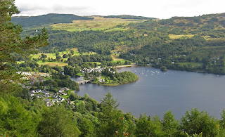
and following it back to the car park. En route I visited the Black Rock viewpoint which provided a grandstand view of Kenmore and Loch Tay.....
So not too bad after all!


1 comment:
Hi Neil.
Reminds me of a hill I climbed with Alex Last year down near peebles.It too was a cairn deep in the middle of a forest but it was a good day out with plenty of wildlife and interest.
Post a Comment