28 April 2012
Participants - Neil and Ben
Where - Cruach na Seilcheig, 380m/1,247', Sub-2k Marilyn, Map 55, NM 854110
It's always good to go to a new area and the sub- 2k's are a good excuse for doing that. The area east of Kilmelford is not one that I had been to before and there were a few sub-2k's there. The trick was to pick the one that would provide the best views and Cruach na Seilcheig looked like the best for that; close to the sea and with no forestry on it. So with a good forecast for the following day, I drove up and spent the night at Connel and was ready for my exploration of new country more or less first thing in the morning.
I left the main road at Kilmelford and took the single track road that eventually went to Taynuilt. After about two miles, I found a place to park at the west end of Loch an Losgainn Mor and took to the hillside from there. There were a few ups and downs but the going underfoot was not too bad- a mix of heather and grass. I would think that this is a prime area for midges in the summer! This is a view back to the place I parked the car from a short distance up the hill.....
and this is a view to the top of the hill from the same spot.....
They give an idea of what the going was like.
This is an area of many lochans. There was one just below the summit, Loch a' Clachain, great if you're a spaniel.....
From about here there was a good view down to Kilmelford.....
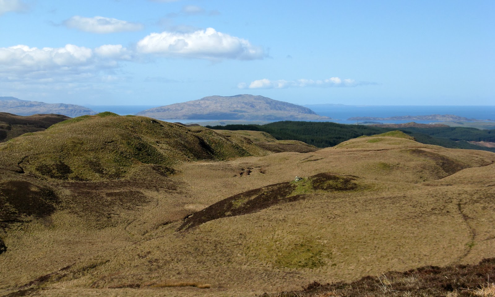
For anyone who climbs this hill on a misty day (which would be a great shame as it is a fantastic viewpoint) there are two cairns and it is the second one that you come to that looks to be higher. From here, the view is down the Sound over many small islands to Jura with the Paps clearly visible. If the weather stays the way it was today then the MBA volunteers will have a great time renovating the new bothy at Cruib on Jura. Here is Ben posing for his usual photograph at the summit.....
And this is the view to another Island Marilyn, Cruach Scarba on the island of the same name.....
The best of the view from the more northerly cairn was to Ben Cruachan.....
There was hardly any wind and it actually felt quite warm so I spent a bit of time at the summit looking at the views (and listening to the first cuckoo of the year). I had certainly made the right choice of hill! Back at the car, I continued my exploration and followed the road to Taynuilt. This is Loch Avich looking north......
As the road goes north, there is more and more forest and views of Loch Awe are few and far between, which was a bit of a disappointmet. This is from one of the few viewpoints looking to Ben Lui which had collected a fair dump of snow overnight.....
A lot of forestry operations were taking place and I noticed that a new wind farm was also to be built at one point. The road surface was good and there was hardly any traffic so it was an enjoyable drive. Hopefully the weather will now settle down and I'll get a few more west coast excursions.
Saturday, 28 April 2012
Sunday, 15 April 2012
Carleatheran
15 April 2012.
Participants - Just me
Where - Carleatheran, 485m/1,592', Sub-2K Marilyn, Map 57, NS 687918
Region 26 in my Marilyn book has been well filled in for some time now but, strangely, Carleatheran has remained unmarked. Yet it is only a few miles from home. I think that it must have been reports of parking difficulties plus the fact that the summit is a long way from the start point that has led me to dismiss it in the past in favour of second ascents of most of the other hills in the section. Anyway, today I was going to put things right.
I found the rough single track road that runs along the foot of Carleatheran and Stronend at the second attempt; I forgot to look at my map and just assumed that it started in Kippen. Doh! There was also plenty of parking- room for at least half a dozen cars- not far past the entrance to Ballochleam farm, which was also the track to the hill. The track wandered up at a gentle incline through a few fields with lots of sheep and lambs in them, and also some cows and calves. Just as well I hadn't brought Ben who would have had to stay on his lead which he hates. I stopped a few times to look at the view back towards the hills of the Southern Highlands, a view that stayed with me all day.....
I have climbed Stronend a couple of times and now that I have climbed Carleatheran as well, I reckon that it is the better hill because the view is with you all of the way. The track continued to the Spout of Ballochleam (about an hour's walking); it wasn't doing much spouting today as the burn was virtually dry. After the Spout, I was out on the open moor where a grassy track headed for the top of Lees Hill. The Southern Highland hills were now on my left and the view behind was to Stronend.....
I was on the plateau but where was the summit? Surely that couldn't be it....a pointed top away in the far distance? I took this photo on the way back just after I met some people who were also heading up; they give a sense of scale to the plateau..... the summit is the small point just sticking up second from left.....
There isn't much height gain on this walk but it sure is a long way and I was glad when the summit cone eventually came into view.....
The track was good for the most part but became a bit boggy in places close to the summit, which hosted a trig inside a large cairn.....
I was glad to be able to sit down for a while in the shelter of the cairn, both for the rest and to get out of the cold northerly breeze. I had my woolly hat on by this stage and also my gloves! This distance across the plateau, the view to the east was now to Stirling and the Ochils.....
I was conscious of the distance that I had to travel to get back so didn't linger too long. It had taken 3 hours to reach the summit but with the advantage of more downhill bits I managed it back in a bit less time (but not much!). There was a good view looking west along the escarpment not long after leaving the summit.....
So that's the highest point of the Gargunnock hills visited. It was a grand airy walk well worth doing, although I was a bit stiff by the time I got back to the car.
Participants - Just me
Where - Carleatheran, 485m/1,592', Sub-2K Marilyn, Map 57, NS 687918
Region 26 in my Marilyn book has been well filled in for some time now but, strangely, Carleatheran has remained unmarked. Yet it is only a few miles from home. I think that it must have been reports of parking difficulties plus the fact that the summit is a long way from the start point that has led me to dismiss it in the past in favour of second ascents of most of the other hills in the section. Anyway, today I was going to put things right.
I found the rough single track road that runs along the foot of Carleatheran and Stronend at the second attempt; I forgot to look at my map and just assumed that it started in Kippen. Doh! There was also plenty of parking- room for at least half a dozen cars- not far past the entrance to Ballochleam farm, which was also the track to the hill. The track wandered up at a gentle incline through a few fields with lots of sheep and lambs in them, and also some cows and calves. Just as well I hadn't brought Ben who would have had to stay on his lead which he hates. I stopped a few times to look at the view back towards the hills of the Southern Highlands, a view that stayed with me all day.....
I have climbed Stronend a couple of times and now that I have climbed Carleatheran as well, I reckon that it is the better hill because the view is with you all of the way. The track continued to the Spout of Ballochleam (about an hour's walking); it wasn't doing much spouting today as the burn was virtually dry. After the Spout, I was out on the open moor where a grassy track headed for the top of Lees Hill. The Southern Highland hills were now on my left and the view behind was to Stronend.....
I was on the plateau but where was the summit? Surely that couldn't be it....a pointed top away in the far distance? I took this photo on the way back just after I met some people who were also heading up; they give a sense of scale to the plateau..... the summit is the small point just sticking up second from left.....
There isn't much height gain on this walk but it sure is a long way and I was glad when the summit cone eventually came into view.....
The track was good for the most part but became a bit boggy in places close to the summit, which hosted a trig inside a large cairn.....
I was glad to be able to sit down for a while in the shelter of the cairn, both for the rest and to get out of the cold northerly breeze. I had my woolly hat on by this stage and also my gloves! This distance across the plateau, the view to the east was now to Stirling and the Ochils.....
I was conscious of the distance that I had to travel to get back so didn't linger too long. It had taken 3 hours to reach the summit but with the advantage of more downhill bits I managed it back in a bit less time (but not much!). There was a good view looking west along the escarpment not long after leaving the summit.....
So that's the highest point of the Gargunnock hills visited. It was a grand airy walk well worth doing, although I was a bit stiff by the time I got back to the car.
Wednesday, 11 April 2012
Cairnkinna Hill
11 April, 2012.
Participants - Just me, there were too many sheep and lambs about to take Ben
Where - Cairnkinna Hill, 554m/1,817', Sub-2,000' Marilyn, Map 78, NS 791018
The weather forecast suggested that heavy showers would build throughout the day so I left early and was booted up and on my way before 10 am. This was a new area for me, I had never been up the valley of the Scar water before, The road was single track but well surfaced and there were a few places to pull in close to the start of the track to the house at Woodend. As I left the car, the long south ridge of Cairnkinna Hill was above me.....
The track led across a field and then through a small wood before reaching the house, although on the outward leg I left the track before the house and headed steeply up to the ridge. There were lots of 4WD tracks on the ridge and as it was also grassy, there was no problem underfoot, unlike my last two outings. It was also quite a gentle ascent after the initial steepness was out of the way and it was just a case of heading for the obvious top of Woodend Craig; the main top is further to the right and you can just make out the cairn in this photo.....
The weather was performing as the forecasters had said; showers were pushing in from the west coast and it was looking a bit black over the hills of north Galloway. I stopped to take a picture in that direction and as I did so realised that there was an object showing up on the lens that shouldn't normally be there......
So I quickly put the camera to zoom and took another one.....
I've no idea what type of plane this is; it was completely silent so I hadn't noticed it coming. Very unlike the usual sound barrier breaking jets that you normally see from the hills. And what it was doing spying on the upper Scar valley also remains a mystery!
With the clouds gathering I carried on to the trig and cairn- yet another massive cairn for quite a small hill.....
The Lowther hills are in the background. I thought that the rain might reach me on the descent but although the head of the valley was obviously catching a shower, it remained dry for me and indeed brightened up again. There was a good view to Criffel and the Solway on the way down.....
This is probably the last of the sub-2k Marilyns that I have to do in this area that I can reasonably do in a day trip from home. Everything else is getting to be too far away. Pity as the south of Scotland is often clear when the weather up north is grim. Still, there are a few that I have walked before that I have not yet blogged that certainly deserve another visit.
Participants - Just me, there were too many sheep and lambs about to take Ben
Where - Cairnkinna Hill, 554m/1,817', Sub-2,000' Marilyn, Map 78, NS 791018
The weather forecast suggested that heavy showers would build throughout the day so I left early and was booted up and on my way before 10 am. This was a new area for me, I had never been up the valley of the Scar water before, The road was single track but well surfaced and there were a few places to pull in close to the start of the track to the house at Woodend. As I left the car, the long south ridge of Cairnkinna Hill was above me.....
The track led across a field and then through a small wood before reaching the house, although on the outward leg I left the track before the house and headed steeply up to the ridge. There were lots of 4WD tracks on the ridge and as it was also grassy, there was no problem underfoot, unlike my last two outings. It was also quite a gentle ascent after the initial steepness was out of the way and it was just a case of heading for the obvious top of Woodend Craig; the main top is further to the right and you can just make out the cairn in this photo.....
The weather was performing as the forecasters had said; showers were pushing in from the west coast and it was looking a bit black over the hills of north Galloway. I stopped to take a picture in that direction and as I did so realised that there was an object showing up on the lens that shouldn't normally be there......
So I quickly put the camera to zoom and took another one.....
I've no idea what type of plane this is; it was completely silent so I hadn't noticed it coming. Very unlike the usual sound barrier breaking jets that you normally see from the hills. And what it was doing spying on the upper Scar valley also remains a mystery!
With the clouds gathering I carried on to the trig and cairn- yet another massive cairn for quite a small hill.....
The Lowther hills are in the background. I thought that the rain might reach me on the descent but although the head of the valley was obviously catching a shower, it remained dry for me and indeed brightened up again. There was a good view to Criffel and the Solway on the way down.....
This is probably the last of the sub-2k Marilyns that I have to do in this area that I can reasonably do in a day trip from home. Everything else is getting to be too far away. Pity as the south of Scotland is often clear when the weather up north is grim. Still, there are a few that I have walked before that I have not yet blogged that certainly deserve another visit.
Wednesday, 28 March 2012
Beinn Dearg (Glen Artney)
27 March 2012
Participants - A solo expedition
Where - Beinn Dearg (Glen Artney), 706m/2,316', Graham, Map 57, NN 697197
A March heatwave! The temperature hit a new record for the month on 3 successive days at Aboyne and temperatures in the area round the central belt got over 20C. Unusually for these temperatures in a prolonged good spell, it wasn't particularly hazy so I decided to take the opportunity of tackling Beinn Dearg in Glen Artney which would be a new Graham/Marilyn for me. It didn't look too long a day looking at the map but it turned out to be a different story on the ground! Certainly, it looked a fair way from the road to the summit.....
I parked in the big car park opposite Glen Artney church and walked back along the road to the house at Dalchuirn, A track skirted the farm buildings, crossed a bridge over the Water of Ruchill and continued to another bridge over a tributary that wasn't named on my map. I took the left hand branch of the track just over this second bridge and followed a rough path/sheep track alongside the burn and a deer fence for about half a mile past a small gorge. This is looking to Beinn Dearg over the gorge.....
Shortly after passing the gorge I came across a gate in the deer fence; although it was heavily wired in I was able to get over it easily. I immediately crossed the burn, no problems today, there was hardly any water in it. The ground between the burn and the start of the climb up the south-east slopes of the hill was the worst of the day- tufty grass which is always difficult to walk across. I headed in the general direction of an old quarry with my objective now straight ahead.....
I was now on grassy slopes and the views were opening up as I gained height. Mor Bheinn and Ben Halton were in view on the other side of the valley, they seem an entirely different proposition being covered in heather......
Another two walkers had set off just behind me and they looked as though they were heading for Mor Bheinn. Then they suddenly changed direction and headed for Beinn Dearg as well. I met one of them at the summit and he confirmed that they had intended to do Mor Bheinn but that they had been stopped by a new deer fence which apparently surrounded the hill.
Beinn Dearg turned out to be one of these hills where you think that you are just about to see the top when another bit comes into view. It was a bit of a struggle in the heat and I was having lots of pauses as I trudged up the grass slopes.....
My Landranger map wasn't particularly helpful when it came to looking for the highest point and I had of course forgotten to check where exactly it was before leaving the house. A 705 top about a mile further on is marked on the map and looked higher than where I was but I was pretty sure that that wasn't it. In fact the top I was on was a metre higher and I knew that the highest point was on the eastern side of the hill. The best of the view was to Stuc a'Chroin and Ben Vorlich......
and this is a slightly zoomed shot of Stobinian and Ben More.....
I made much better progress on the way back but it was certainly a tougher hill than I had anticipated. But its nice country and it was only a short drive from home.
Participants - A solo expedition
Where - Beinn Dearg (Glen Artney), 706m/2,316', Graham, Map 57, NN 697197
A March heatwave! The temperature hit a new record for the month on 3 successive days at Aboyne and temperatures in the area round the central belt got over 20C. Unusually for these temperatures in a prolonged good spell, it wasn't particularly hazy so I decided to take the opportunity of tackling Beinn Dearg in Glen Artney which would be a new Graham/Marilyn for me. It didn't look too long a day looking at the map but it turned out to be a different story on the ground! Certainly, it looked a fair way from the road to the summit.....
I parked in the big car park opposite Glen Artney church and walked back along the road to the house at Dalchuirn, A track skirted the farm buildings, crossed a bridge over the Water of Ruchill and continued to another bridge over a tributary that wasn't named on my map. I took the left hand branch of the track just over this second bridge and followed a rough path/sheep track alongside the burn and a deer fence for about half a mile past a small gorge. This is looking to Beinn Dearg over the gorge.....
Shortly after passing the gorge I came across a gate in the deer fence; although it was heavily wired in I was able to get over it easily. I immediately crossed the burn, no problems today, there was hardly any water in it. The ground between the burn and the start of the climb up the south-east slopes of the hill was the worst of the day- tufty grass which is always difficult to walk across. I headed in the general direction of an old quarry with my objective now straight ahead.....
I was now on grassy slopes and the views were opening up as I gained height. Mor Bheinn and Ben Halton were in view on the other side of the valley, they seem an entirely different proposition being covered in heather......
Another two walkers had set off just behind me and they looked as though they were heading for Mor Bheinn. Then they suddenly changed direction and headed for Beinn Dearg as well. I met one of them at the summit and he confirmed that they had intended to do Mor Bheinn but that they had been stopped by a new deer fence which apparently surrounded the hill.
Beinn Dearg turned out to be one of these hills where you think that you are just about to see the top when another bit comes into view. It was a bit of a struggle in the heat and I was having lots of pauses as I trudged up the grass slopes.....
My Landranger map wasn't particularly helpful when it came to looking for the highest point and I had of course forgotten to check where exactly it was before leaving the house. A 705 top about a mile further on is marked on the map and looked higher than where I was but I was pretty sure that that wasn't it. In fact the top I was on was a metre higher and I knew that the highest point was on the eastern side of the hill. The best of the view was to Stuc a'Chroin and Ben Vorlich......
and this is a slightly zoomed shot of Stobinian and Ben More.....
I made much better progress on the way back but it was certainly a tougher hill than I had anticipated. But its nice country and it was only a short drive from home.
Thursday, 22 March 2012
Meall Tairneachan
22 March 2012
Participants - Neil and Ben
Where - Meall Tairneachan, 787m/2582', Corbett, Map 52, NN 807544
I'm not sure why but I really, really struggled on this one today. The ground wasn't particularly rough, it wasn't overly steep and it was a relatively short distance. Its definitely getting harder to crank my body into action at the start of a years hillwalking!
The only time I did this hill before- with Farragon Hill- I walked up the road to the baryte mine that sits between the two Corbetts. A poor route and I had been meaning to do this hill again for ages via something a lot better. There was some activity going on near the start of the walk in connection with the building of the Beauly to Denny power line but it did not affect access to the hill. Anyway, I parked at the old Tomphubil Lime Kiln at the highest point of the B846 Aberfeldy to Tummel Bridge road. There was an information board that told me that the Kiln was built around 1865 to meet a growing demand for lime to improve land for pasture and crops. The Kiln went out of use in the early 1900's.....
After a look at the Kiln, I got my boots on and set off up the hill. The views around here are dominated by Schiehallion.....
An old wall and a new deer fence went up the hill from the car park and the best going was between the two; a path of sorts has started to develop. This is looking up to the first top of Meall Odhar Mor.....
and looking back down to the road with Schiehallion in the background. I could make out both the new path and the remains of the one it replaced up this popular Munro.....
After Meall Odhar Mor the ridge got a bit knobbly with a few downhill sections but at least the westerly tops of the Corbett were now in view.....
I ground my way on still following the old wall to the steepest section of the day, the climb to the 780m top. Up that and the main top was in sight. Thank goodness!
It was only a further 10 minutes to the trig, following the high ground as much as possible. This is the approach to it with Farragon Hill in the background.....
and this is the view back the way I had come with Schiehallion dominating the view as usual.....
There was no question of carrying on to Farragon Hill today; anyway, I fancy trying a southerly approach to it if I ever do it again. So it was back the way I had come. On the way back I spotted a truck on the road from the mine so it must still be operational. It had been a fine day- the first really warm day of the year- but I was nevertheless glad to see the car!
Participants - Neil and Ben
Where - Meall Tairneachan, 787m/2582', Corbett, Map 52, NN 807544
I'm not sure why but I really, really struggled on this one today. The ground wasn't particularly rough, it wasn't overly steep and it was a relatively short distance. Its definitely getting harder to crank my body into action at the start of a years hillwalking!
The only time I did this hill before- with Farragon Hill- I walked up the road to the baryte mine that sits between the two Corbetts. A poor route and I had been meaning to do this hill again for ages via something a lot better. There was some activity going on near the start of the walk in connection with the building of the Beauly to Denny power line but it did not affect access to the hill. Anyway, I parked at the old Tomphubil Lime Kiln at the highest point of the B846 Aberfeldy to Tummel Bridge road. There was an information board that told me that the Kiln was built around 1865 to meet a growing demand for lime to improve land for pasture and crops. The Kiln went out of use in the early 1900's.....
After a look at the Kiln, I got my boots on and set off up the hill. The views around here are dominated by Schiehallion.....
An old wall and a new deer fence went up the hill from the car park and the best going was between the two; a path of sorts has started to develop. This is looking up to the first top of Meall Odhar Mor.....
and looking back down to the road with Schiehallion in the background. I could make out both the new path and the remains of the one it replaced up this popular Munro.....
After Meall Odhar Mor the ridge got a bit knobbly with a few downhill sections but at least the westerly tops of the Corbett were now in view.....
I ground my way on still following the old wall to the steepest section of the day, the climb to the 780m top. Up that and the main top was in sight. Thank goodness!
It was only a further 10 minutes to the trig, following the high ground as much as possible. This is the approach to it with Farragon Hill in the background.....
and this is the view back the way I had come with Schiehallion dominating the view as usual.....
There was no question of carrying on to Farragon Hill today; anyway, I fancy trying a southerly approach to it if I ever do it again. So it was back the way I had come. On the way back I spotted a truck on the road from the mine so it must still be operational. It had been a fine day- the first really warm day of the year- but I was nevertheless glad to see the car!
Thursday, 15 March 2012
Millstone Hill
14 March 2012
Participants - Neil and Ben
Where - Millstone Hill, 409m/ 1,342', Sub-2,000' Marilyn, Map 38, NJ 676202
It looked as though the weather was going to do a repeat performance of the day before- cloudy early with sunshine breaking through in the afternoon. So I took my time getting started. I had climbed Bennachie a few years previously but it has a southern outlier, Millstone Hill, which is a sub-2,000' Marilyn in its own right. Just right for a short day before doing the drive home. I took this picture of it- with the river Don in the foreground and the Mither Tap to its right- later in the day.....
The start point was the Forestry Commission's Donview car park. No problems route finding today, there was a signposted trail all the way to the top.....
The trail headed steeply up through a dark bit of forest with wooden steps to aid progress; higher up it became a stone staircase.....
The trees gradually thinned, it became less steep and we were soon approaching the top.....
The main reason for climbing this hill, apart from getting the Marilyn "tick" of course, was for the fine view of the Mither Tap of Bennachie that you get from the cairn.....
Bennachie is another one that I will have to go back to on a future visit. But that was it for this wee trip; a few days sunshine and some more interesting small hills visited in what I think is very pleasant countryside.
Participants - Neil and Ben
Where - Millstone Hill, 409m/ 1,342', Sub-2,000' Marilyn, Map 38, NJ 676202
It looked as though the weather was going to do a repeat performance of the day before- cloudy early with sunshine breaking through in the afternoon. So I took my time getting started. I had climbed Bennachie a few years previously but it has a southern outlier, Millstone Hill, which is a sub-2,000' Marilyn in its own right. Just right for a short day before doing the drive home. I took this picture of it- with the river Don in the foreground and the Mither Tap to its right- later in the day.....
The start point was the Forestry Commission's Donview car park. No problems route finding today, there was a signposted trail all the way to the top.....
The trail headed steeply up through a dark bit of forest with wooden steps to aid progress; higher up it became a stone staircase.....
The trees gradually thinned, it became less steep and we were soon approaching the top.....
The main reason for climbing this hill, apart from getting the Marilyn "tick" of course, was for the fine view of the Mither Tap of Bennachie that you get from the cairn.....
Bennachie is another one that I will have to go back to on a future visit. But that was it for this wee trip; a few days sunshine and some more interesting small hills visited in what I think is very pleasant countryside.
Lord Arthur's Hill
13 March 2012
Participants - Neil and Ben
Where - Lord Arthur's Hill, 518m/ 1,699', Sub-2,000' Marilyn, Map 37, NJ 513 198
The clouds were breaking up and the sun was starting to appear when I got back down Benaquhallie. It was only a short drive to the next sub-2,000', Lord Arthur's Hill just west of Alford. A search of the internet suggests that the hill might be named after Lord Arthur Forbes, a local landowner in times past. This is a view towards the hill taken later in the day.....
According to the map there are lots of tracks on the hill but I decided to approach it from the A944, from the houses at Littlewood Park. There wasn't really any space to park the car at the entrance to the driveway to the house but there was a handy quarry area about 300m back along the road so I parked there. The only problem was having to walk with the dog along a main road but fortunately the traffic was very light.
After passing the big house, I came to some more buildings. A track, not marked on my map, headed left from here and seemed to head directly up the south ridge passing to the left of a wooded area so I took that. In fact, it met one of the tracks marked on the map not that far from the top.....
This was another hill with a big cairn, again in a strategic position overlooking the surrounding countryside. Maybe Lord Arthur surveyed his lands from here, although the cairn looks as though it might be quite modern.....
A few yards further on the highest point was marked by a trig. This is looking west towards The Buck (there was a lot of heather burning going on).....
Morven dominated the view to the south-west with Lochnagar beyond, this pic is zoomed.....
The estate seemed to be burning heather on the east side of the hill quite close to the summit so rather than go back by a different route on that side of the hill I just returned the same way. From the way down, there was a good view across the Howe of Alford with this morning's hill, Benaquhallie, in the distance.....
Participants - Neil and Ben
Where - Lord Arthur's Hill, 518m/ 1,699', Sub-2,000' Marilyn, Map 37, NJ 513 198
The clouds were breaking up and the sun was starting to appear when I got back down Benaquhallie. It was only a short drive to the next sub-2,000', Lord Arthur's Hill just west of Alford. A search of the internet suggests that the hill might be named after Lord Arthur Forbes, a local landowner in times past. This is a view towards the hill taken later in the day.....
According to the map there are lots of tracks on the hill but I decided to approach it from the A944, from the houses at Littlewood Park. There wasn't really any space to park the car at the entrance to the driveway to the house but there was a handy quarry area about 300m back along the road so I parked there. The only problem was having to walk with the dog along a main road but fortunately the traffic was very light.
After passing the big house, I came to some more buildings. A track, not marked on my map, headed left from here and seemed to head directly up the south ridge passing to the left of a wooded area so I took that. In fact, it met one of the tracks marked on the map not that far from the top.....
This was another hill with a big cairn, again in a strategic position overlooking the surrounding countryside. Maybe Lord Arthur surveyed his lands from here, although the cairn looks as though it might be quite modern.....
A few yards further on the highest point was marked by a trig. This is looking west towards The Buck (there was a lot of heather burning going on).....
Morven dominated the view to the south-west with Lochnagar beyond, this pic is zoomed.....
The estate seemed to be burning heather on the east side of the hill quite close to the summit so rather than go back by a different route on that side of the hill I just returned the same way. From the way down, there was a good view across the Howe of Alford with this morning's hill, Benaquhallie, in the distance.....
Subscribe to:
Posts (Atom)