Tuesday, 29 December 2015

Beinn Lora

27 December 2015

Participants: Neil and Ben
Where: Beinn Lora, 308m/1010', Sub-2k Marilyn, Map 49, NM 919377

The last day of the Oban Christmas break and the first sight of the sun. I decided to go for Beinn Lora above Connel which I had climbed a few times before, it is a good viewpoint for minimal effort. The forestry had improved a number of the paths since I was last here although the part above the forest and before the final climb resembled a bog, not surprising given the wet December we have endured. I took a few photos.
 
From the other side of the Connel bridge.....
  

The view to Mull from about half way up.....
 
 
 The airport from the summit.....

 
The trig with the Etive hills background.....


Mull from the summit.....

 
The view up Loch Etive to a cloud covered Ben Cruachan.....


A good way to finish the year.

Monday, 28 December 2015

Beinn Mhor (Lorn)

22 December 2015

Participants: Just me
Where: Beinn Mhor (Lorn), 194m/637', Sub-2k Marilyn, Map 49, NM 798216

There are a number of Beinn Mhor's (big hill) about, some "Mhor" than others. What this one lacked in height however, it made up for in its situation.
 
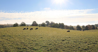
We were staying near Oban for Christmas week and the forecast was poor, to say the least. However, I was determined to add this one to my list of sub-2k's and to reach a total of 30 new hills for the year. On day one of the holiday, I was taking Ben out for a walk and noticed that some clearer weather appeared to be coming in from the west. So when I got back to the chalet, I decided that I had better go for it, in case the rest of the week was awful- it almost was. So I changed into my hillwalking gear and drove to the south end of Loch Seil on the road to the slate islands where there was a large lay-by opposite a track that would take me most of the way to Beinn Mhor.
 
I knew from passing this way previously that there were usually cows in the fields here so I had left Ben behind. Sure enough, I soon came across a herd, here with the hill in the background.....
 
 
I left the track at its high point and headed for the upper slopes, soon picking up a rough ATV track which actually went to the summit. I also picked up a near gale force wind, which was not so welcome. Here are some shots taken on the way up. Looking south with Scarba just visible on the horizon.....
 
 
and a zoom shot, lots of rough country south of here.....
 
 
and across to the hills of Mull, which seemed to be catching the rain.....
 
 
The path wound around the west side of the hill, here approaching the summit area.....
 
 
Even at this modest height, I had difficulty standing up in the gale that was now blowing and photography was decidedly problematic. Especially so as the trig was perched close to the edge of cliffs and other steep ground falling all the way down to the sea. What a situation! I was probably lucky to visit in such wild conditions.


I hung about for 10 minutes or so until I noticed a large, very black cloud heading my way. However, the rain somehow missed me and by the time I arrived back at the car, the sun was making a brief appearance.....
 
 
So a spur of the moment decision to go for the hill had paid dividends!


Sunday, 18 October 2015

Another Beinn Mhor (Mor/More)

16 October 2015

Participants: Just me
Where: Beinn Mhor (Grantown), 471m/1`,545', Sub-2k Marilyn, Map 36, NH 993281
 
The Mountain Bothies Association AGM was being held at Newtonmore, the weather was continuing to be excellent, so I travelled up a day early with this Marilyn behind Grantown- on- Spey in mind. It was very frosty and foggy when I set off from Newtonmore but as soon as I turned up Glenbeg, just short of the town boundary, I was into sunshine. Sheep in a field beside the parking spot at the end of the road made a good photograph.....
 
 
and the hill was soon clearly visible.....
 
 
The walk up the track was very pleasant. The leaves were starting to come off the trees although thanks to the extended warm weather this year and the subsequent lateness in leaf fall, the colours were not as good as usual.....
 
 
The track took me out on to the hill. I had wondered if there would be any shooting going on but the hill was not covered in the SMC guidance nor could I find out which estate owned the hill. So I was more than a little dismayed to find 3 shiny 4x4's parked at the edge of the heather. I had a look but there were no warning notices and I couldn't see any sign of anyone so I just carried on. In fact, I saw no evidence of humans at all during the walk although I expect that they might have seen me. The hill provided nice and gentle walking with short heather, occasional traces of a path and a gentle angle.....
 
 
I wasn't putting off time in case the shooting party appeared and I wanted this hill for my Marilyn list having travelled so far. I was at the top in around an hour from the car. Here are a couple of views of the moorland to the north-east and the north.....


The Spey valley was still fog bound so it made a good foreground looking over to the Cairngorms.....
 
 
zoomed.....
 
 
and to Mount Keen.....
 
 
I could have stayed longer at the top but I reckoned that discretion was the best policy so just headed back down. Then I went and sat around the car park half way up Cairngorm for an hour or two.

Tuesday, 13 October 2015

Brilliant weather on Cruach Tairbeirt

13 October 2015

Participants: Neil and Ben
Where: Cruach Tairbeirt, Sub-2k Marilyn on Loch Lomond-side (again)
 
This is one of my favourite sub-2k Marilyns for views and I have climbed it on a number of occasions. Today, the weather conditions were perfect. The actual walk was a bit of a problem though. There were a lot more fallen trees than when I was last here so the early stage of the walk was a bit of an obstacle course. Once out of the forest it was a different problem. The vegetation was still luxuriant, probably boosted by the late summer weather, and the path difficult to follow in places. The grass and ferns concealed a number of holes in the path and I think that I was lucky only to discover two of them! This route certainly now requires care.
 
All was worth it however when I reached the summit. I'll let the photographs tell the tale.
 
Nearing the top, the Cobbler and Beinn Narnain appear.....
 
 
Ben at the trig.....
 
 
The Luss hills.....
 
 
Ben and the Brack, the Cobbler and Beinn Narnain.....
 
 
The Cobbler and Beinn Narnain.....
 
 
Ben cooling off in a convenient summit puddle.....
 
 
Loch Sloy and the dam.....
 
 
Zoom of Loch Sloy and the dam.....
 
 
Head of Loch Lomond and the Crianlarich hills.....
 
 
Loch Long and the Brack....
 
 
And the best of all, Loch and Ben Lomond.....


Tuesday, 29 September 2015

Hill of Tillymorgan and Hill of Foudland

28 September 2015

Participants: Just me
Where: Hill of Tillymorgan, 381m/1,249', Sub-2k Marilyn, Map 29, NJ 652348 and Hill of Foudland, 467m/1,531', Sub-2k Marilyn, Map 29, NJ 603332
 
I made the short drive from Alford to the Glens of Foudland to climb these two Marilyns. It wasn't quite as sunny as the previous day but still very clear and if anything a bit warmer. I decided to climb Hill of Tillymorgan first so drove to the farm at Kirkton of Culsalmond. There was no obvious place to park and no one about to ask so I drove back down the hill to the A920 where there was a convenient lay by. It only added a few hundred yards to the walk. The hill was signposted, a track which went through a number of fields before entering some woodland.....
 
 
The path sort of disappeared after leaving the woodland but the way was obvious- through some old slate quarries which littered the top of the hill. Apparently, quarrying went on into the latter part of the 19th century. It made for a rather industrial looking landscape.....


A barbed wire fence separated the quarrying area from the more grassy top of the hill and the mound containing the trig. It overlooked the Glen's of Foudland wind farm......


but a better view was due north to another of the Aberdeenshire Marilyns, Knock Hill.....


There was also a view south to Bennachie.....


I returned the same way and moved the car a couple of miles back along the road to the wee village of Colpy where I parked. It was then a walk of about a mile along a tarmacked road to the farm of Jericho and then a good track up through some woodland to the start of the track to the masts which were almost at the top of Hill of Foudland. Here are some photos of the approach.....


The masts are a local landmark and are quite impressive close up........


The masts could have been the highest point but apparently not; it is the trig point a further half mile across the moor.....

A less impressive summit this one, the hill in the middle distance is Tap o'Noth.......


There was a good view of the Hill of Tillymorgan on the way down.....


It took me about an hour and a half to climb Hill of Tillymorgan and a shade under 3 hours to climb Hill of Foudland. Then it was back down the road. It had been another interesting trip to Aberdeenshire.