Sunday 30 June 2024

Drum Maw (Romano Bridge)

 29 June 2024

Where: Drum Maw, 445m/1,460', P 93m, Tump, OS 72, NT 177 471

Drum Maw from Mountain Cross.....

I parked at the cemetery which is just east of the village and joined the Cross Border Drove Road.....

The route initially went through some forestry before emerging at a col where there was a great view of  more hills to the south- typical Borders scenery.....

Drum Maw from near the col.....

Immediately on leaving the forest, I turned up the grassy east slopes of the hill- quite steep but with traces of a path. The summit was not far and was marked by a cairn. There were excellent views of the Pentland Hills to the north-east and the Broughton hills to the west with Tinto in the far distance.....


Another pleasant hill.

Tuesday 25 June 2024

Archibald Gair Head

23 June 2024

Where: Archibald Gair Head, 494m/1,621, P 91m, Tump, OS 78, NS 983 141

I decided to investigate one of the Tumps in the western arm of the Clyde wind farm south of Abington. A track went to within a few metres of the summit; one of the advantages of wind farms as this would have been a difficult hill otherwise due to the terrain. There was a large parking area at the start, Gate E.....

Heading up the track, it was a gentle incline.....

The summit area was rough and the high point was a knoll, although I wondered if it was man made.....


Looking north to the Lowther Hills and south to the Moffat hills.....


Heading down.....


Friday 21 June 2024

Kildoach Hill and the Hunter Blair Monument

 19 June 2024

Where: Kildoach Hill, 354m/1,162', P 53m, Tump, OS 77, NS 396 040

The Hunter Blair Monument is Craigengower Hill south of Straiton with Craigengower Hill being a top of the Tump Kildoach Hill. I parked opposite the cemetery where the track to the Monument started.....

It went through a field then a wood before going very steeply up to the Monument.....


The 20m high granite Monument commemorates Lt. Col. James Hunter Blair MP who died in the Crimean War. It is an impressive obelisk seen from miles around......


There was a tremendous view down over Straiton as far as the Arran hills on the distant horizon.....

Kildoach Hill wasn't far away and only a few metres higher......

But it involved a walk over rough, boggy ground. On the way back, I followed an ATV track which took a circuitous route but avoided the tussocks and bog. There were a number of possible high points but I was confident that I found the correct one. There was a good view south to the Galloway hills; the only downside was that there was a wind farm close by.....


Saturday 15 June 2024

Lochlyoch Hill and Howgate Hill

 12 June 2024

Where: Lochlyoch Hill, 529m/1,736', P 43m, Tump, OS 71/72, NS 930 342 and Howgate Hill, 450m/1,476', P 71m, Tump, OS 71/72, NS 911 342

These two Tumps form the westward extension of Tinto Hill and indeed could be climbed with it if you had two cars available. I decided to climb them from the south, the B 7055, and found a parking spot c.300m east of Burnhead Cottage from where a track went up to (and past) a col between the two hills. The view up the track with Howgate Hill on the left and Lochlyoch Hill on the right.....

The main objective of the day was Lochlyoch Hill and I tackled it first, leaving the main track before reaching a quarry on to another track which went steeply through the forest. This emerged on to open slopes not far from the summit.....


The highest point wasn't marked and there was a good view east to Tinto....


and west to Howgate Hill.....

I retraced my steps to the main track (Howgate Hill ahead).....

and carried on past the old quarry to the col from where another track started very steeply up the slopes of Howgate Hill. This almost disappeared higher up where the forest had been cut down but there were traces of a path through the brash. Again the summit was unmarked, I made it to be just inside the trees.....


There were good views of Lochlyoch Hill and Tinto on the way back down......


And then it was a case of retracing steps on the track back to the car.....


Friday 7 June 2024

Lindston Hill, Pennyvenie Colliery, Patna Hill

 6 June 2024

Where: Lindston Hill, 126m/413', P 41m, Tump, OS 70, NS 376 169; Pennyvenie Colliery, 247m/810', P 32m, Tump, OS 70, NS 484 067' and Patna Hill, 260m/853', P 47m, Tump, OS 70, NS 405 109

A day of sunshine and heavy showers, just right for doing these hills which are situated in the Ayr- Dalmellington corridor. Lindston Hill was a drive up but to do it properly I parked at the foot of the road and walked up the few hundred yards to the top. The highest point is probably in the garden of the house but for the purposes of the bag, the point immediately outside the gate is sufficient.....


I then drove through Dalmellington for Pennyvenie Colliery, an old bing although you wouldn't know it once on it as the vegetation has fully taken over. It was a very pleasant short walk along the ridge and the top provided a good view over Dalmellington and north to the Marilyn Benbeoch.....


I the drove back along the road to Patna and a 40 minute wait in the car while a very heavy rain shower passed over. There was good parking at the start of the track up the hill and then a grassy trod to the obvious high point. Good views down to Patna with the Arran hills just visible on the western horizon. The first picture is the hill from the east, not from the starting point which is from the south....


Tuesday 4 June 2024

The Water of Leith Walkway

STAGE 1, BALERNO to SLATEFORD 

29 January 2024

This part of the Way follows the path of the former Balerno branch railway line which closed in 1968. I had done this walk a number of times when I lived in Edinburgh although it was more than 20 years since the last occasion. What a difference! Former old mill buildings and waste land had gone and been replaced by attractive new housing. And the old railway tunnel at Colinton had been turned into a visitor attraction! I followed the track as far as Colinton and Craiglockhart Dell where I diverged down into the Dell itself re-joining the track just before reaching Slateford. This made a walk of c.6 miles. There is an information board at the start in Balerno, just north of the High School.....

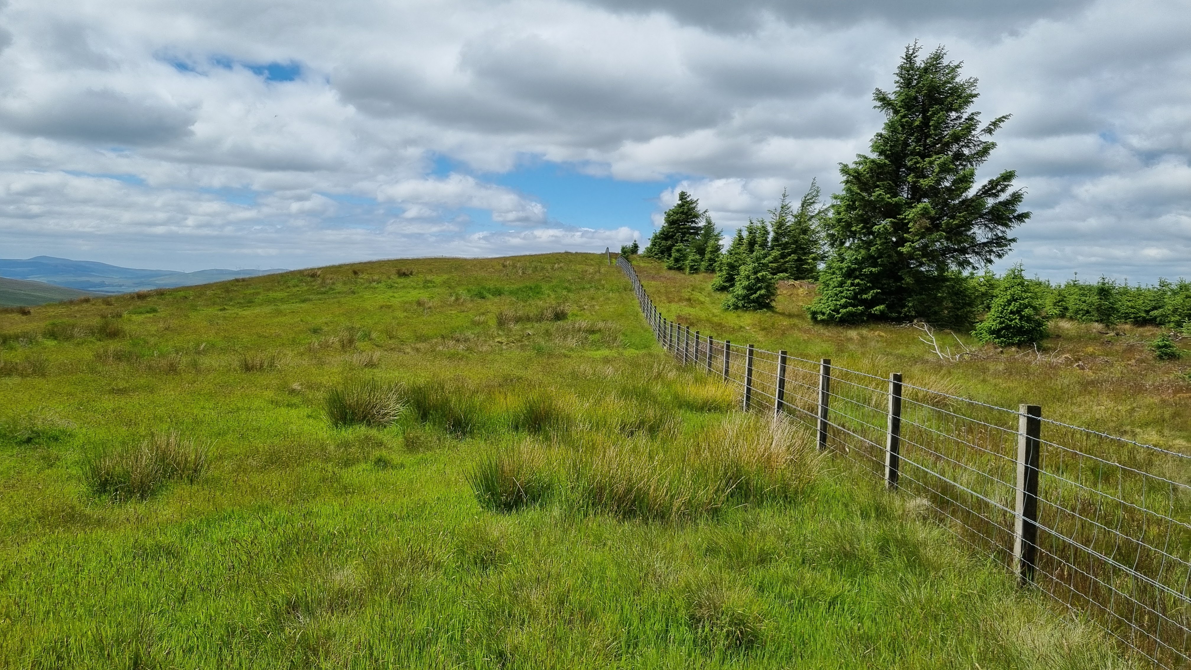
The route is mostly fairly hemmed in and soon passes some new houses but there are also some more open aspects.....


The track passed through an avenue of trees on the approach to Currie....


The bridge here is over 500 years old and is said to be the oldest one on the river.....

There were more housing developments at Juniper Green and the track then passes under firstly the City bypass and then Colinton Road.....


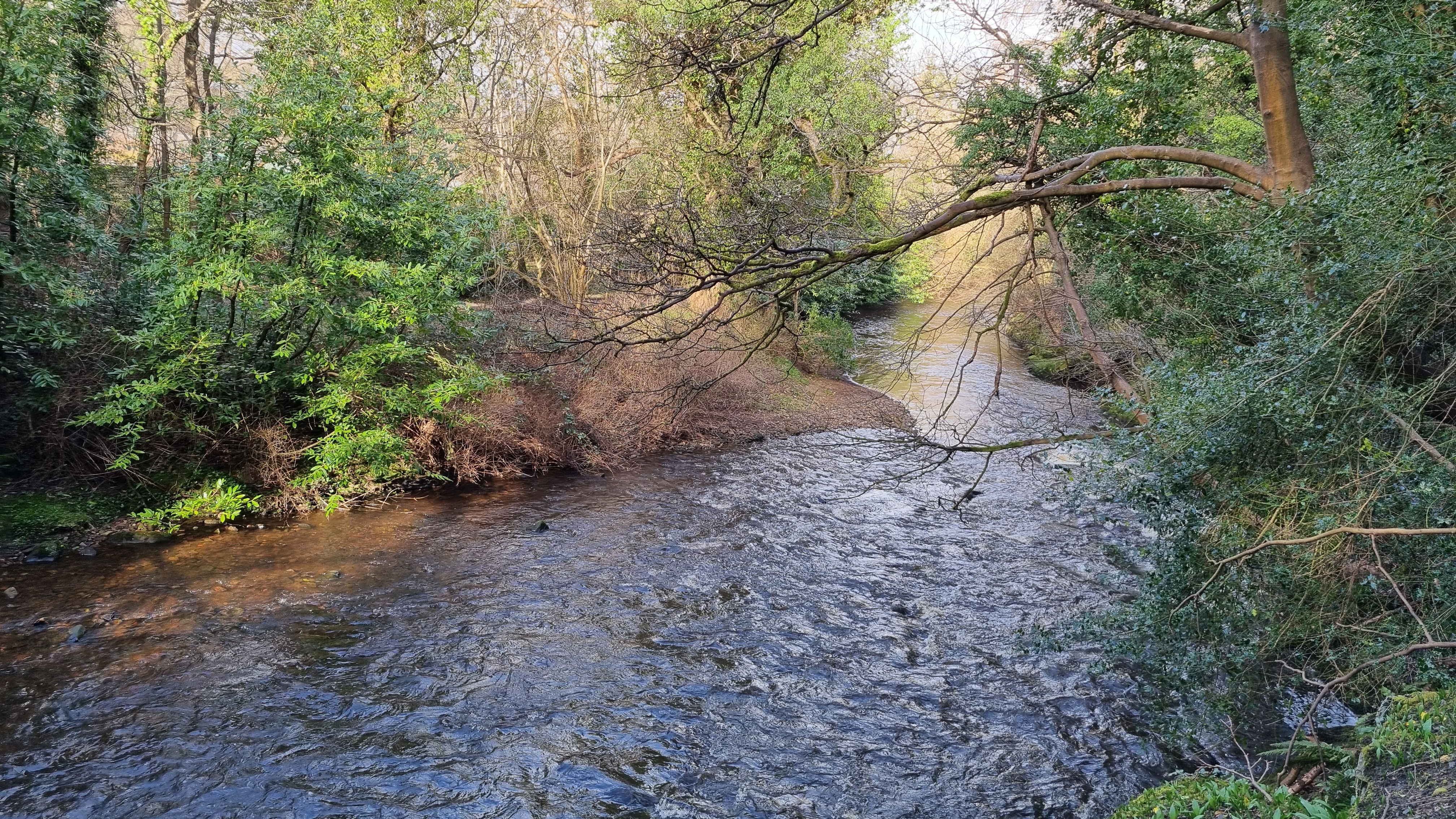
This is an interesting and picturesque part of the river with an old weir and some rapids.....


I liked this sign.....

The Colinton tunnel was now ahead. I remember it as being gloomy with lots of graffiti and a bit scary. No longer. The local community have created  a mural linking the story of the railway with local heritage. Along one wall are the illustrated words of Robert Louis Stevenson's poem "From a Railway Carriage". These illustrations link across the roof and connect to images reflecting local heritage on the opposite wall. The entire length of the tunnel- 140 metres- has been covered. Stunning! Here are photos of some of the murals.....


Past Colinton village I left the track and descended into Colinton and Craiglockhart Dell,,,,,


The river flowed on and passed a grotto.....


And then I was at Slateford, dominated by an aqueduct and viaduct, with the Water of Leith Visitor Centre providing an excellent interactive exhibition, information about the river and a welcome cup of coffee. 


STAGE 2: SLATEFORD to STOCKBRIDGE

12 April 2024

I decided to break the remaining 7 or so miles down into two stages as there was a lot to see now that I had reached the urban area. So it was back to Slateford and a cup of coffee before I started the walk. Initially the path was shut in between the river and an big area of allotments and the only real point of interest was a view of part of HMP Saughton above the opposite river bank.....

The Way crossed the main Edinburgh - Kilmarnock road at Chesser and shortly after entered Saughton Park.....

The main point of interest for me was the formal gardens, including a glass house, a peaceful area to sit for a bit.....


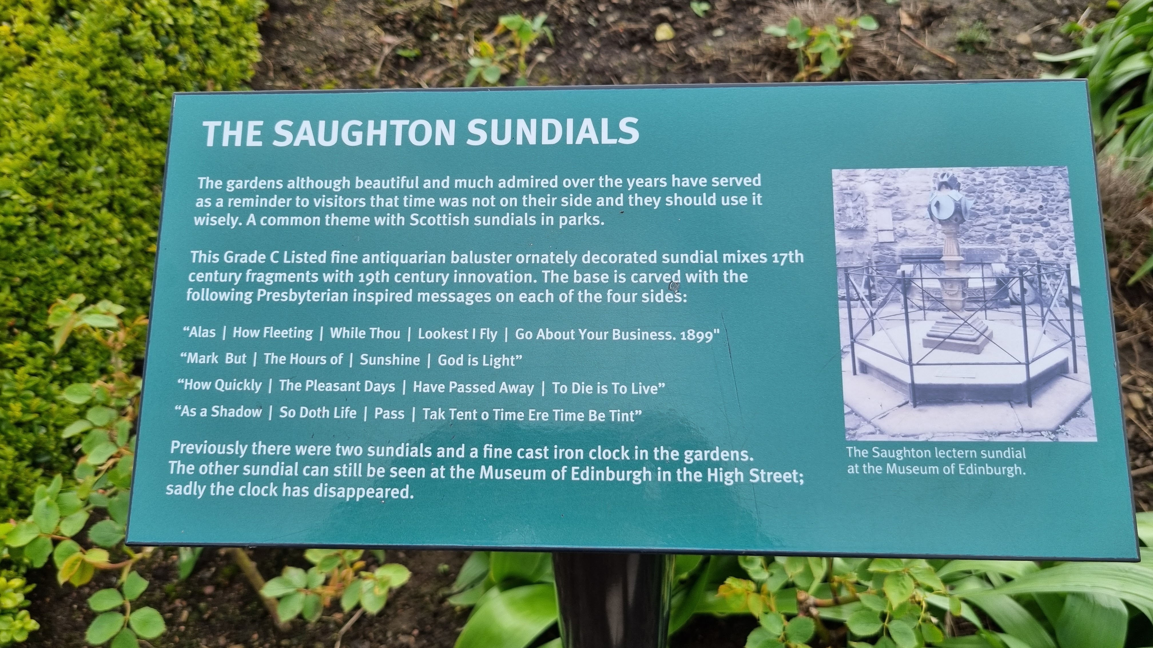
There was another item of interest in among the neat gardens, the Saughton sundials.....


Leaving the park, the Way briefly carried on a road, passed under the railway line and turned north with Corstorphine Hill in the distance.....

It then approached Murrayfield stadium, passed it to the north, and crossed the main Edinburgh - Glasgow road at Roseburn.....


The river was tranquil here.....


A statue by Antony Gormley stands in the water at the back of a weir. It is one of 6, 5 of which stand in the river....  


The next section approaching Dean Village is the area of the former Bells Mills complex, now home to a hotel and a sports complex.....


There were a couple more weirs as the path approached the village, the major one previously powering all 8 mills on this part of the river.....


Dean Village is a major attraction, the peace and quiet of the previous stretch lost to hordes of tourists. It was not difficult to see why; it fully justifies its World Heritage Site status. I spent quite a bit of time here.....


The path now passes under the Dean bridge, which carries the main road between Edinburgh and the Forth bridges.....


The next point of interest was St Bernard's Well, a spring crowned by a circular temple featuring a statue of Hygeia, the Greek Goddess of Health and Cleanliness.....


Shortly after, the Way transfers to a street and enters Stockbridge.......


Where there is another Antony Gormley statue...... 


STAGE 3: STOCKBRIDGE TO LEITH

8 May 2024

I took the bus down to Stockbridge to do the final stage of the walk.....


The way soon passed a housing development on the opposite side of the river, The Colonies. These were built between 1861 and 1911 to provide low cost housing away from the slums of the Old Town.....


Next was Canonmills where the route diverged onto the pavement for a bit and passing the well known Canonmills clock.....


But it was soon back to the riverside park and more greenery as the route entered St Marks park, another green area of the City that I didn't know existed.. And another Anthony Gormley statue in the river.....


Bonington was next, and what a difference to what I remembered. The old mill buildings had been transformed into modern offices, warehouses and houses.....


and another statue.....


soon after, Leith came into view, signalling the end of the Way.....


It had been a fascinating walk, mostly rural but with some urban stretches, taking me to parts of the city that I didn't know existed and showing how the city had changed over the last few decades.